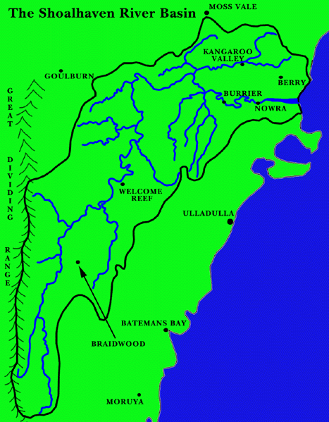
The Shoalhaven River is one of the major rivers on the N.S.W. coast. It is 300 kilometers long and has a catchment area of 6,920 square kilometers. The headwaters rise on the eastern slopes of the Great Dividing Range about 40 km inland from Moruya at an elevation of 1350 m. |
Floods |
| Description of catchment | Map of catchment |
| What to do :- |
Description of catchment |
From there the river flows north to near Major Creek. Below Major Creek the river sweeps generally to the north east where it is joined by Jembaicumbene, Gillamatong, Reedy and Boro Creeks. Braidwood is located on Gillamatong Creek about 8 km upstream of the Shoalhaven River Junction. About 22 km north of Braidwood the river is joined by a major tributory, the Mongarlowe River which rises near Sugarloaf Mountain in the Budawangs. The Corang River also rises in the Budawangs and joins the Shoalhaven river about 5 km west of Nerriga. Below Nerriga the river is joined on the right bank by another major tributary the Endrick River. Below Welcome Reef the river enters a narrow gorge and travels through mountainous country to approximately 16 km west of Nowra. Nerrinunga Creek, a tributary of the Shoalhaven River, rises in the hilly country to the east of Lake Bathurst and enters the river 8 km downstream of the Endrick River. Bungonia Creek commences in hilly terrain about 15 km east of Goulburn and passes through a steep canyon before entering the Shoalhaven River. The southern tributaries of the Shoalhaven River downstream of the Endrick River drain a large plateau area bounded by the Turpentine Range on the south east. The four main tributaries in this area are Ettrema, Bundundah, Danjera and Yarramunmun Creeks all of which drain into Yalwal Creek which joins the Shoalhaven River about 18 km west of Nowra. The remaining major tributary is the Kangaroo River, the upper tributaries of which rise in the Robertson - Moss Vale Plateau, and flows through steep mountainous country for 48 km being joined by Tallowa Creek and Bundanoon Creek just before entering the Shoalhaven River about 30 km upstream of Nowra. About 16 km upstream of Nowra the river emerges onto a plain and from Burrier to the mouth flows through wide alluvial flats. These flats extend northwards up the valley of Broughton Creek to the town of Berry and southwards to the vicinity of Jervis Bay. |
|
What to do's |