
• welcome |
places of interest
Summer holidays are the perfect time to become acquainted with beautiful Jervis Bay. |
|
| Altogether, 12 places are individually listed in the Register of the National Estate (the national heritage inventory compiled by the Australian Heritage Commission), while the entire bay, an area of approximately 30,000 hectares has recently been included on the Register of the National Estate. If you are interested in natural history or discovering more about the fascinating story of human occupation of this part of the coastline, there are several local authorities and organisations happy to provide information. These include the Shoalhaven City Council, the NSW National Parks and Wildlife Service and ANCA. |
| The following information has been provided from the database of the Register of the National Estate and more details can be obtained from the Australian Heritage Commission GPO Box 1567, Canberra, ACT 2601. Remember, if you visit the sites, treat them with respect — our heritage is here for us to learn from and appreciate, as well as to pass down in good condition to future generations.... |
 |
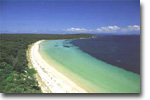
| JERVIS BAY AND SURROUNDS This listing includes the waters of the bay, the two headlands (Beecroft Peninsula and the northern part of Bherwerre Peninsula), a narrow strip of the offshore continental shelf and a belt of land around the bay, including several townships. This region contains a great diversity of landscapes, ranging from beaches, lakes, estuaries and cliffs to the forested slopes and heath-covered plateaux. |
 |
Landform The bay was formed by down-folding of the earth’s crust. This is in contrast to other bays of comparable size in eastern Australian which were formed by the flooding of river valleys. |
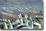
| The two fresh water lagoons, Lake Windermere and Lake McKenzie, both have deep layers of sediment containing diatoms, pollen, spicules and skeletons of aquatic fauna. They provide evidence for scientists to reconstruct past environments of the region, as well as valuable habitat today for water fowl and aquatic animals. |
 |
 |
Wetlands There are a number of estuarine wetlands located around the bay, including Currambene Creek which contains saltmarsh and mangrove communities that contribute to the productivity of the bay. All provide habitats for waterbirds, crustaceans and molluscs and a nursery for other aquatic species. |
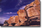
| Aboriginal heritage Important archaeological sites, some of special significance to the local Aboriginal communities, are found within the area. There are many middens along the shores. Some sandstone overhangs which traditionally provided shelter are known to contain occupational debris. |
 |
| European history Captain James Cook sighted the Bay in 1770 and named St Georges Head and Longnose Point. The township of Huskisson is noted for its shipbuilding history. The early pastoral settlement over the region reflects an important phase in Australian history. |
Images ©
Continue..