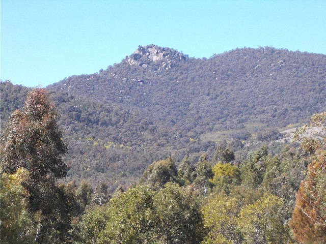
Ginraltar Peak as seen from the ascent up the ridge on the way to Nil Desperandum
We arrived in the park at 10.10am and drove past the adventure playground to Greens car park, where we put on our daypacks and hiking boots. We had decided on walking to Nil Desperandum, one of the original homesteads in Tidbinbilla. The track notes inform us it is a 14km return walk, but that distance includes a section of track starting and finishing at the park visitors centre. By commencing at Greens, we can cut the walk back to a 9km return walk.
We set off at 10.20am, following a familiar track we had followed over a month ago on a recent recce of the area and descended to an open picnic area that was once the Green Family homestead on the banks of the Tidbinbilla River. George Green and his friend George Hatcliffe were responsible for the construction of many buildings in the region, including Nil Desperandum.
Following a bush track we quickly crossed the foot bridge across the cascades of the Tidbinbilla River and passed the walk register. The track took us alongside the river for a short distance where areas were set aside for revegetation and soon the track found us walking just below an unsealed access road we had walked along recently. Eventually the track came out onto the access road and we crossed to the other side where an ochre sign post revealed the way to Nil Desperandum.
The bush track took us through about 250 metres of vegetation before bringing us out onto a large unsealed road leading uphill. We turned left and ascended, taking photographs of the ridgeline in front of us that featured our last destination here in Camels Hump (or Camels Back depending on which sign you look at) and Pierce Hill. Turning around we got good views of the boulder strewn Gibraltar Peak.
Ginraltar Peak as seen from the ascent up the ridge on the way to Nil Desperandum
Our road linked up with Gilmore's Road near the top, but before we turned right onto Spur 2 Trail, we turned left to take a quick look at some roadside rock outcrops less than 100 metres away. The biggest was worth photographing. On the way back to the intersection I noticed rock formations in the vegetation to our left and suggested we take an off-track detour to have a look. The forest floor was thick with ferns, but I thought the formation resembled one we had been looking for during our recent recce - I was wrong, but we did locate an intriguing bush track in the forest. It may have been a well used animal pad.
The wind was stiff and cold, but I didnít want to put on a down jacket as I would soon overheat. Instead, I chose my rain jacket as a windcheater and it worked out quite well, adjusting the front zipper as I heated up or cooled down. Back on Spur 2 Trail we ascended gradually, passing by a dead Red Belly Black Snake, a warning that now spring was upon us, snakes were coming out of winter hibernation. We have no idea what killed the snake, it wasn't very big, no bigger than 2 foot long. It was likely to have been run over by a vehicle using the trail.
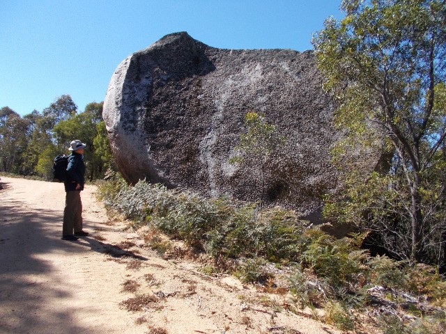
Craig stands beside one of the large boulders on the roadside
We turned right at Split Rock Trail, helped by the ochre posts with white arrows pointing the way. We now seemed to be walking along a ridge top that gave tantalising views across the valley. At the intersection with Boundary Trail we turned left and started to descend.
The descent was quite steep and I wondered how hard the walk back was going to be after lunch. Craig also held this thought as we negotiated the steep and slippery road with its loose stones. We descended alongside a wire fence and as the trail levelled out at the bottom of the hill a sign revealed we were walking alongside a privately owned property.
Through the trees we caught our first sight of Nil Desperandum. We arrived at 11.30am to a homestead surrounded by a fence. Outside the fence was a grassy low hill dominated by more large rock boulders, old discarded and rusting farm machinery, a toilet block and an interpretive information board.
Nil Desperandum is a pise construction built by Green and Hatcliff in 1895 for Irish settler Henry French Gillman (the man who inspired and fought for Tidbinbilla to be turned into a national park) Nil Desperandum, meaning "Never Despair". There is no immediate water supply nearby, except for rainwater tanks. Water had to be carried from Hurdle Creek originally in buckets, later in 44 gallon drums. Nil Desperandum was almost destroyed during the 2003 bushfires. It has been restored as a vital part of the valley's history and can be hired out for Bushwalkers accommodation.
We had a look around. The building, being isolated, was unlocked. Individual rooms contain up to 3 camp cots and there is enough accommodation for up to 8 people. The old kitchen has been fully restored. Out back is a large verandah complete with large modern gas barbecue, but the back garden has seating and an old fashioned wood burning barbecue.
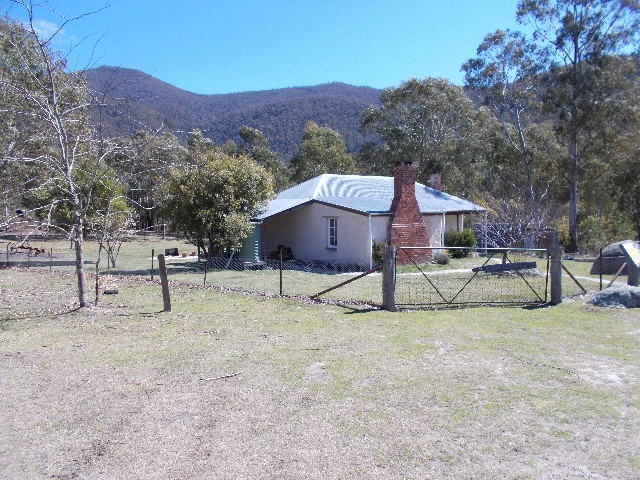
The homestead known as Nil Desperandum (Never Despair)
At 11.50am Craig and I chose a grassy spot on the knoll just above the homestead where we sat for lunch and enjoyed the afternoon sunshine. We weren't looking forward to the initial ascent back, so we made sure we enjoyed our lunch break and took longer than usual.
We were off and returning to the car at 12.20pm. We chatted about some of our upcoming walks as we ascended the hill. Craig took one look at one ascent and asked "Did we descend that?" We had but as we got close we realised we had only descended half the hill, our road comes in halfway down. We were so busy chatting away we didn't realise we had completed the ascent until we reached the Spur 2 Trail intersection. Craig was amazed but I was aware of how good his walking fitness had come along with the extra hiking we have done recently.
As we descended back to the car park we passed by a young couple heading towards Nil Desperandum. They must have walked in from the visitor centre as there was no other car in the Greens car park when we arrived back at 2.25pm.
This is one of the better walks in Tidbinbilla and well away from the popular tourist 20 minute walks in the park. Since this report was written there have been changes to the route after a section along this trail was closed to cater for a new wallaby breeding enclosure. The new route includes a very scenic bush track, a historical circuit walk near the homestead and the new trail takes you past Man On A Horse Rock.