Man On A Horse Rock - Very Impressive
We arrived at the Tidbinbilla's entrance around 9.40am and stopped for a quick look in the visitor's centre. I suggested to Craig that we drive into Greens picnic area and see where the Jedbinbilla Trail arrows take us. Hopefully we will be more successful in locating a rock formation known as 'Man On A Horse' or 'The Horseman Rock'. We had attempted to find this formation last year but had been thwarted by a maze of trails which really confused matters. We arrived at the Greens picnic area car park at 10.00am, put on our hiking boots and rucksacks and followed the short track down to Greens picnic area.
The area is level and covered in lush grass. There are a selection of wood barbecues and nearby is the Tidbinbilla River. As we followed the track to the river crossing we were totally amazed at how dry the river was. Last year there was a healthy water flow, all we could see were a few stagnant looking pools of water and all the rocks on the dry river bed. This place really needs some rainfall, and soon.
After crossing the footbridge we followed a well-defined track through the forest alongside the river for about 200 metres where the track crosses an unsealed road. The track on the other side has a sign telling us to continue on the track to Nil Desperandum, which we had also visited in 2018. We turn left and follow the road.
After a couple hundred metres we pass below some rock outcrops to our right. I decided they looked too interesting to pass up and told Craig I was going to take a quick look. I scrambled up the slope and negotiated the thick scrub to reach what appeared to be a large granite boulder. Could the back end reveal Horseman Rock? I noticed there were faint tracks heading off into the bush and followed one. The track circumnavigated the entire outcrop which revealed onion style splitting as well as a whole group of smaller boulders. Quite photogenic, but not what we are looking for.
As I made my way back I noticed Craig had scrambled up from the road. I informed him our rock formation wasn't here and we scrambled back down. Continuing on for a short distance we soon came to the orange sign with the black arrow we had seen on our last walk here. Instead of carrying on up the road, we decided today, to follow the track. We always believed this would take us to Jedbinbilla, but we later found out that the name Jedbinbilla refers to the entire area we were walking in, roads, tracks and paddocks. Before we headed off, Craig noticed we were following the Tidbinbilla River on our left and he could see some orange signage on the other side and part of a road. We agreed this would be worth checking out on the way back.
We now followed the track through the dry scrub and soon came to another dirt road with another orange signpost. We decided to follow the road and arrow despite heading uphill on what was now quite a warm day. The road passed by what appeared to be an old farm. As we topped the rise we were greeted with another road intersection. Do we head straight ahead or turn left where it looked like the road split in two again. The way straight ahead looked more interesting and I suggested so.
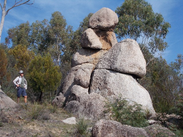
Following the road I saw what could be more rock outcrops through the trees, but as we passed by some trees on the roadside my eyes suddenly caught sight of an outcrop Craig and I had been searching for since last winter. It was taller than I expected but it certainly resembled a man on a horse for most of the angles we looked at. We scrambled up the slope and circumnavigated the structure. It did indeed resemble a horseman riding a horse, right down to the arms and legs, the latter of which appeared to straddle the horse's girth. I snapped away with my camera getting a range of shots. We were interested in exactly where we were on the official tourist map we got from the visitor's centre. Not all the roads are marked and as for the rock formation, no mention here at all, though there is information on a board at Mountain Creek car park, which is where we first learned of this formation. We decide to drive over to Mountain Creek car park after the walk and compare the map on the information board to the pamphlet we are carrying.
Man On A Horse Rock - Very Impressive
We were able to pinpoint exactly where the Horseman formation is by comparing the two maps and checking the shape of the surrounding roads. It is no wonder we had trouble finding this attraction, the main road we had originally followed is marked as a minor road and the minor road we found the Horseman on is marked as a major thoroughfare. Craig and I both marked the rock formation on our pamphlet maps for future reference.
We worked out it had taken us just 50 minutes to reach the rock formation, and that included my deviation to explore another set of rocks early on. We now set off back to the car, a walk that would only takes us 30 minutes to complete.
When we arrived at the track intersection we stopped for a 5 minute break. This was obviously an old farm as pieces of metal and rusting sections of cable could be found on the ground. When we continued we followed our route in until we arrived back at our main road next to the dry Tidbinbilla River and crossed over to inspect the road and signs we had seen on the walk in.
We were amazed to find foot tracks on the other side of the river and realised we had stepped out on to the adjacent picnic area to Greens at Blewitts Picnic Area. From here we were able to follow an interesting foot track through the forest to Greens Picnic Area. It is now obvious the other route takes us in a wide arc out of our way before almost coming a full 360 degrees back to almost where we started.
We arrived back at Craig's car and took the drive to Mountain Creek car park to compare maps. Since this walk has been completed, the trail to Man On A Horse Rock has been included into the new route to Nil Desperandum. Just keep your eyes open on your left as you ascend the hill on the fire trail.