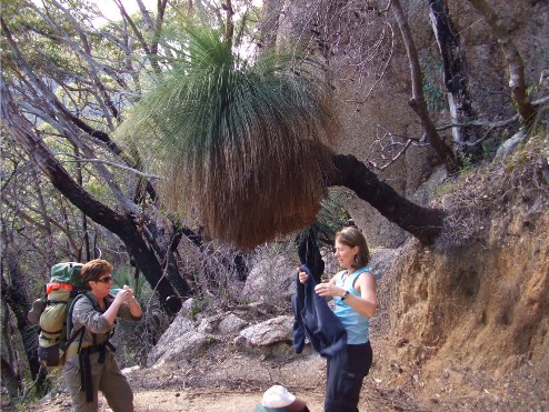
Sandra & Kynie take a break under a large Grass Tree on the switchbacks near Windy Saddle
On Saturday 25th August 2007 fellow Shoalhaven Bushwalkers Kynie Evison and Sandra Kelley joined me for our four day hike through the Southern Circuit of Wilsons Promontory National Park in Victoria. The idea was to drop me and the three well loaded rucksacks at Telegraph Saddle whilst Kynie & Sandra drove to the Park Rangers Office at Tidal River to book in our permits and park the car. The 3.5km road from Tidal River to Telegraph Saddle was quite steep, so the plan was for Kynie & Sandra to make quick time without the heavy burden of fully loaded packs as the park's shuttle bus only operates in the peak tourist season.
Today was cool and windy and the sky was overcast with light clouds which looked like it would clear. The forecast for the four days we would be walking was for cloudy conditions, but we accepted that considering the amount of wet weather multi-day hikes we had done over the past two years. Within 20 minutes of being dropped off, Kynie & Sandra turned up, lucky enough to have caught a ride from a couple of day hikers and 5 minutes later, at 9.40am we set off along the track, eastwards towards Sealers Cove.
In 2005 bushfires raged through the park, burning most of the vegetation. Only small pockets of forest remained untouched. During the walk we would make our way through forests of blackened timber and lifeless trees, skeletons of forests once green with vegetation. Yet in the less than 2 years since the fires came through, it was amazing to see how well the forest regrowth had come on. In some ways the fires had made it possible to get great views that were once unseen through thick scrub, in others it was sad to be taking photographs that included blackened timber. The unburnt sections were appreciated even more whenever we came across them.
Sandra & Kynie take a break under a large Grass Tree on the switchbacks near Windy Saddle
The walking track initially descends lightly through regenerating forest but soon starts its steady ascent towards Windy Saddle utilising a series of switchbacks or zig-zagging tracks. I felt the switchbacks made tackling the ascent much easier than utilising a direct ascent of steps or steep slope and we seemed to make good time. The recovering forest was dominated by grass trees, Ferns and paperbark and the forest was full of birdsong as we ascended. By 10.30am we arrived at Windy Saddle, an open grassy area surrounded by bush on the flanks of Mount McAlister to the south-west and Mount Ramsay to the north. Only 300 metres above sea level, the saddle really didn't offer much in views, but the lush grass and small wooden platform made for a great spot to take a break. By now the clouds had completely cleared, revealing a deep blue sky above.
We continued eastwards, descending to Sealers Swamp by a long track that sidled Mount Ramsay, crossing many gullies, one with a small waterfall. This area seems to have escaped the bushfires and we passed through many pockets of sub tropical rainforest dominated by moss covered rocks and tree trunks. After a further 4km we reached the swamp which was mostly dry. A wooden walkway follows the entire crossing. We crossed picturesque Blackfish Creek and after crossing a quaint narrow wooden bridge over Sealers Creek it was only about 100 metres of sandy track before we stepped out onto the golden sands of Sealers Cove. A 600 metre walk down the beach to the southern end brought us to the mouth of Sealers Creek where we removed our footwear and rolled up our trouser legs for the short crossing to the camping area. The water was ice cold but refreshing to our feet. On the other side we entered the bush by a narrow signposted track and within metres, entered the Sealers Cove camping area.
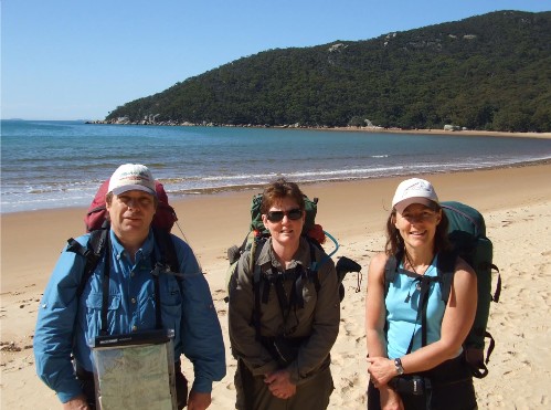
Paul, Sandra & Kynie on Sealers Beach
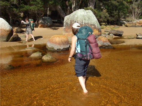
Kynie crossing Sealers Creek at low tide
Once we had selected a suitable site for our tents we explored the area, finding an ingenious running water set-up next to the creek where a pipe emptied fresh running water into a hollow log before running down the bank and back into the creek. We found all the campsites bar Roaring Meg Creek had these contraptions and they proved to be most useful during our hike, even though we played it safe by boiling or treating the water first before drinking. After having lunch during which we were visited by a couple of very inquisitive Crimson Rosellas we unpacked our rucksacks and pitched our tents.
With the bulk of the afternoon still ahead of us we decided to explore the area. We walked back down to where we crossed Sealers Creek, the tide low enough for us to walk about 200 metres upstream where, apart from getting some excellent water reflections, we spied two black swans in the water further upstream. We then decided to walk the entire length of the beach to the rocks at the northern end of the cove. The sand very firm under our bare feet and the cold water most invigorating. As we made our way back to the southern end of the cove we noticed the tide was coming in, though not fast enough to worry us. We still had enough time to check out the boulder strewn coastline at this end of Sealers Cove with its red & green lichen coverings before returning to our campsite to prepare dinner.
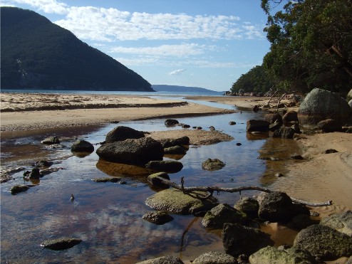
The mouth of Sealers Creek at the southern end of Sealers Cove
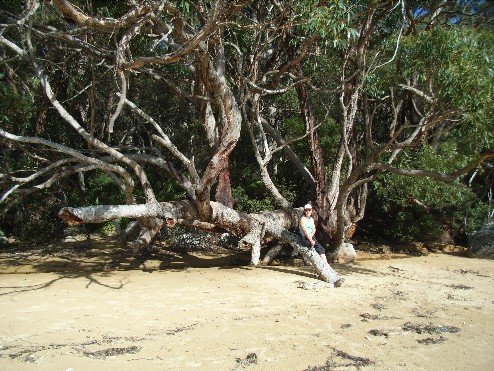
Kynie on an oddly shaped tree at the back of Sealers Beach (K Evison collection)
Next morning we fixed ourselves breakfast, dismantled the tents and packed the rucksacks and by 8.30am we were on the track to Refuge Cove. There was some low cloud about but we could see it was breaking up to reveal another perfect blue sky as we followed the track as it ascended towards Horn Point. Again this section seems to have avoided the devastation of the 2005 bushfires, even some of the wildflowers were out early, adding some colour to the track. It took just one hour to reach the rock platform above Horn Point. From here we had great views back north over Sealers Cove to The Cathedral and a reasonable view of Refuge Cove to the south.
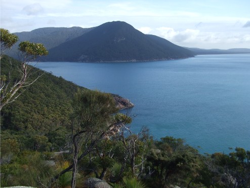
Above Horn Point. The view north of Sealers Cove and The Cathedral
We now descended through thick forest and patches of Sub-Tropical Rainforest to come out onto more golden sand on a small beach on the northern end of the cove. We crossed the sand and entered another track which ascended then descended over the rocky point in the middle of Refuge Cove to the Boat Camp on the southern beach. This camp was remarkable. It featured a wooden fence which had signs with the names of boats carved by owners of the many vessels that had moored here over the years. These were intermingled with carved whale bones and even footwear depicting boat names. We now followed the beach south and found the track to Refuge Camp.
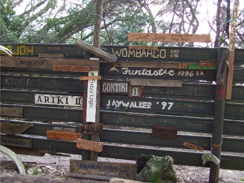
The amazing fence at the Refuge Cove Boat Camp
From Refugfe Camping Area we started the hard gruelling ascent to Kersops Saddle. Along the way there are a couple of granite slabs where great views can be taken of Refuge Cove while you catch your breath, then it's on and upwards 200 metres high along more switchbacks, an ascent that seems to just keep rising until finally, just after Midday we stepped out onto an open rocky area that afforded a good view south of Waterloo Bay. We had arrived at Kersops Saddle. A signpost here informed us it was a short 300 metre walk to the summit of Kersops Peak so we decided to have lunch there. The ascent was only another 40 metres and it was well worth the little effort. We had great views of Waterloo Bay with its aqua blue water and white sandy beach. Further to the south was a tantalising view of South-East Point and the lighthouse. Behind us to the north were magnificent views of the coastline. We enjoyed our lunch in the warm sunshine while an occasional breeze cooled us down after the hot climb. After lunch we returned to the track and prepared for our descent to Waterloo Bay.
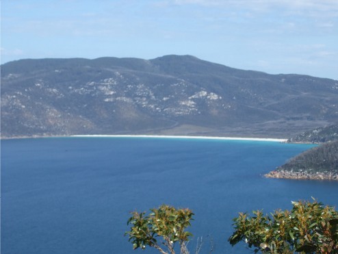
The view of Waterloo Bay from Kersops Peak
We descended through the forest quite quickly to North Waterloo Bay, stepped out onto the tiny beach which we crossed to find another track which initially headed inland. This track is quite narrow but very scenic. It was also very undulating as it skirted the ridge above the coastal rocks providing pleasant coastal views. Eventually at 2.45pm we descended onto the white sand of Little Waterloo Bay and quickly found the track to the campsite. We were the only people here so we were able to pick out the choicest campsites and found the best to be just 25 metres from the now expected waterpipe on the creek, though a decent 200 metre walk to the toilet block which featured a big rarity, a flushing toilet instead of the usual self-composting pit set-up.
We pitched our tents, then went for a stroll along the beach. The water was freezing but it soothed our very tired and sore feet. I noticed I had acquired a small blister on the ball of my right foot and Kynie had similar on her toes. These would have to be taped before we set off tomorrow. We returned to camp by 4.30pm and started to prepare our dinners. We had the usual suspects hanging around, this time a Crow and three Magpies. We had finished eating before it got dark and with light fading it started to get quite cold. All three of us are feeling stiff and sore from the day's exertions and we're certainly not looking forward to more ascending tomorrow. Sandra got us up doing stretching exercises and even a little Thai Chi - I found it a bit too violent for my liking, but the stretches seemed to help relieve some of the stiffness in the joints and muscles. By 7.30pm it had become so cold we all decided to retire to our tents for an early night.
Next morning we headed through the campsite to the track that would take us over the rocky coastline to Waterloo Bay. It was already a bright sunny day with absolutely no cloud in the sky at all. It was going to be a most unseasonably warm late winter's day. The short track had a few ascents, just enough to warm up the muscles and before we knew it we were standing at the northern end of the beach at Waterloo Bay. We had over one kilometre of soft white sand to negotiate and by the time we had reached the southern end of the beach our legs were quite stiff. The only witness to our humorous attempts at crossing the beach was a lone wallaby sitting on the grass atop a dune behind the beach.
The track recommenced just 50 metres from the southern end of the beach. It felt good to be standing on solid ground once again, but not for long. The track, known as 'The Lighthouse Track' soon started to ascend, away from the coastal heath and into the now familiar burnt forest as it started to climb up to the Boulder Range - so named after the granite tors and boulders seen throughout the range, up and up it went until we were above Home Cove, then in another series of switchbacks, climbed further upwards past blackened trees and white granite boulders. Only the ground cover was green as the vegetation has just commenced its regrowth here. Many rest breaks to catch our breath and enjoy in the views were taken until the track levelled out and we found ourselves on top. Less than 100 metres further on we came to a large rock slab, high above the ocean which gave some magnificent views. We had climbed 280 metres since we left the beach at Waterloo Bay.
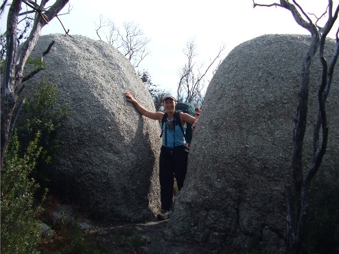
Kynie appears between two boulders at the top of the Boulder Range after the climb from Waterloo Bay
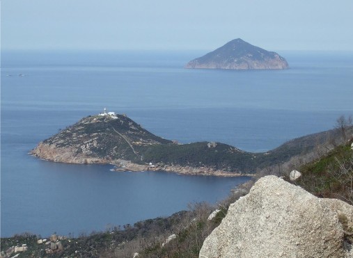
The view of South East Point and the lighthouse from the rock slab
The rock slab gave us views of almost all the coastline to the north and it felt like we were almost looking down onto South-East Point and the lighthouse. The sea was eerily calm and there seemed to be hardly a wave breaking in sight. The track now moved inland and started to descend into thick forest. After some distance we reached an intersection and descended to South-East Point. We ascended a short slope to the helipad, past some amazing rock formations, three large boulders, one of them appeared to be balancing on the smallest of points and resembled a Henry Moore sculpture. Then it was onto the main ascent, a narrow concrete path which was very steep. We reached the top and made our way past a complex of colonial looking buildings to the lighthouse proper. We found an open grassy section for lunch that gave us not only great views of the lighthouse, but also the coastline along the southernmost tip of mainland Australia and all the surrounding offshore islands.
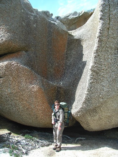
Sandra poses in front of one of the amazing boulders near the lighthouse (K Evison)
The steep descent back down to the helipad was almost as difficult as the ascent. We reached the trackhead and headed west. Again we found ourselves ascending, this time along a very long 4.4km track and gaining about 240 metres in height, the only respite being a short 50 metre side track for a wonderful lookout that gave us views of South-East Point and the lighthouse from a western angle. We continued onwards and upwards through the burnt countryside, wondering when we would reach the intersection of the Telegraph Road. Eventually we arrived, we turned right and headed north along this winding road for about 700 metres until we came to a track on the left side. This is a short cut to Roaring Meg Creek campsite but it does descend quite steeply to a side creek before crossing two small ridges before descending to Roaring Meg Creek. That meant two more ascents, only small but after today's ascending they were more than enough, though we found the clearest water at one of the small creeks in the gullies and took the opportunity to top up our Platypus hydration bags. The track passed through more fire blackened forest. Eventually we crossed a new wooden bridge over Roaring Meg Creek and arrived at the lower campsite at 3.50pm. The lower campsites we thought were rather poor and looked very damp so we climbed the ridge to the top campsites where we found the ground was very hard and the bushfires had been very fierce here judging by how badly burnt the trees were.
We wasted little time in getting our tents pitched, and prepared dinner as darkness was fast upon us. It was 5.45pm by the time we got the stoves lit and then the possums came and joined in. The next couple of hours were spent in between the now regular Thai Chi and stretching exercises and chasing the pesky possums away from our tents and gear. We took the extra steps of making sure all our food was doubly secured in plastic bags, put in our rucksacks and placed in our tents. It was 8.20pm by the time we had run the possums out of our camp and we wasted little time in retiring to our tents for the night. We needed a good rest after today's heavy walking. However, our night wasn't over just yet. We were all awoken after midnight, firstly by the rising full moon which, inside our tents, gave the effect that it was morning and then after 1.00pm by the sound of howling winds coming through the gullies, this kept us awake for quite a few hours.
We were up and out of our tents by 6.00am. The sky was clear and the winds had died down, but there was some ominous looking clouds to the south that were not to bother us today. By the time we'd had breakfast and packed up it was 8.10am and we set off on the track behind the toilet block. Again a much shorter and more scenic option than walking the full length of Telegraph Road. Initially taking us through what remained of the forest for 500 metres the track ascended onto scrubby heathland, dominated by the still upright but now unused steel telegraph poles and undulated its way for just over 2km to join up with the Telegraph Road just south of Martins Hill. We now followed the road for some distance northwards as it descended towards Halfway Hut.
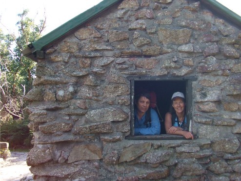
Paul & Kynie at Halfway Hut
Halfway Hut, originally called Martins Hut is a solid stone building which was originally built for workers servicing the telegraph line to the lighthouse. Built halfway between Telegraph Saddle and the lighthouse, it is partially hidden in the forest and features a picturesque camping area complete with fresh water tank and a pit toilet. We arrived there at 9.20am and explored the area making a mental note to consider this as a definite campsite for a future hike in the Prom. Being made of stone, the hut has survived numerous bushfires in the area over the years. We continued northwards along the Telegraph Road which now took us through badly burnt Ti Tree forest. Instead of walking through a tunnel of green we now passed through a forest of black lifeless trees surrounded by a carpet of green undergrowth of ferns and weeds. Just over one kilometre later we passed a side track to Waterloo Bay and 100 metres further on, was the left hand track to Oberon Bay. This was a similar road to the Telegraph Road, especially the burnt out Ti Tree forest, but the track was very sandy and thankfully was mostly level as it made its 3.5km journey to the beach.
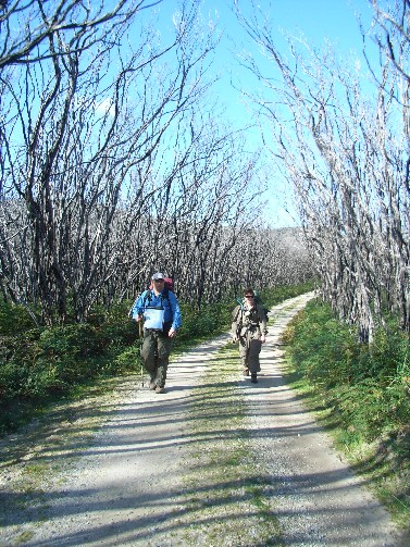
Paul & Sandra make their way through a forest of burnt Ti Tree (K Evison)
We arrived at Oberon Beach at 10.20am and located the camping area on the brackish Frasers Creek where we stopped for a break. We still have the western coastal walk to go to finish our trip but we have left the open dirt roads behind us. We made our way onto Oberon Beach and headed north. At the northern end of the beach we waded across Growler Creek. North of the creek along the coastline were more boulders with the orange red lichen, similar to those found on the eastern side of the Prom. The track, which quickly ascended around the headland to Little Oberon Bay showed evidence the bushfires were pretty fierce here too and the vegetation has not recovered so well, though it is making some slow progress.
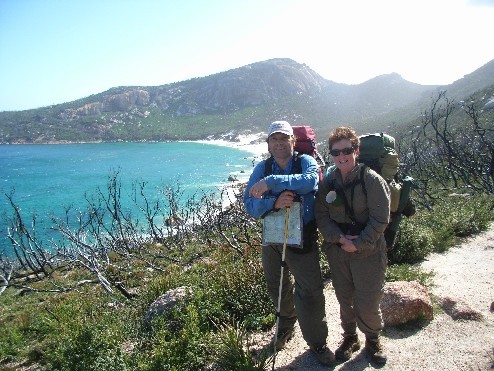
Paul & Sandra above Little Oberon Bay with Little Oberon in the background (K Evison)
The track soon descended to Little Oberon Bay and we crossed a small beach of soft white sand. Not far away we again climbed a long dune and found the track which climbs high above and around a small peninsula known as Norman Point with Little Oberon above us, a tall hill featuring more granite tors and boulders. As we commenced the descent to Norman Beach it was decided to take lunch at 12.45pm on the track, where the scenery would be better than the village of Tidal River. We found a spot on a large rock slab perched above the ocean, a cool breeze welcome in the hot midday sun. The views of the offshore islands to the north-west complimented the scene.
After a short lunch we set off for the final leg of our
four day hike and 10 minutes later had stepped onto Norman Beach. We then
followed the main track behind the dunes which followed a tunnel of unburnt
Ti Tree forest, giving us an insight into what the Telegraph Road section
may have looked like prior to the fires. At 1.45pm we arrived back at Tidal
River, loaded our rucksacks into Sandra's car and handed our permits back
in at the Ranger Station. It has been a most memorable four days of hiking.