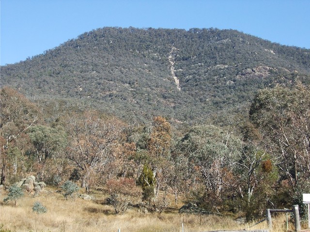
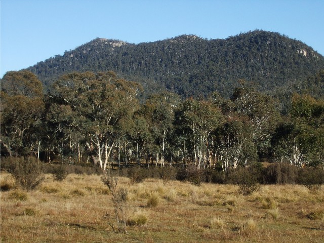
Mt Tennant, with it's unmistakable scar eises up from the Naas Road just south of Canberra
You're asking yourself "What the Hell is a Sub 24 Hour bush walk?" Sean Sunley is a new member of the Canberra Bushwalkers who has been restricted with his abilities to do a number of multi day hiking trips due to long working hours. With many of the regular household chores left to be done over the weekend, Sean came up with this great idea. The Sub 24 Hour Bushwalk. The general idea is that the walk would start on the Saturday afternoon immediately after lunch - hikers would walk a certain track through interesting countryside and reach a suitable camping area late afternoon, pitch tents, enjoy a social evening round the campfire or fireplace, then next morning, return to the car park in time for Sunday lunch via the same route or via a circuit route.
This weekend's walk would be the fourth that Sean has led and would easily be the hardest so far. On all four walks, Sean has had an excellent turn-out with no less than 10 hikers each time. His idea looks like being very popular. This walk would take us into Namadgi National Park and follow the Australian Alps Walking Track. It would be a circuit walk which would see us making a side trip to the summit of Mt Tennant and have us camping overnight at Bushfold Flats. The temperature forecast for Canberra this weekend was for five degrees celsius up to 22 degrees, though in Namadgi one should always subtract 4 degrees. The forecast was for clear sunny days and frost overnight.
Mt Tennant, with it's unmistakable scar eises up from the Naas Road just south of Canberra
For the first time in more than 25 years I would be joined by Craig Rayner for a multi day hike. Craig had not been able to do any serious hiking since he had suffered fromÝ a mystery illness since 1990. Over the past few years he had been able to return to doing some easy one day walks, but when I mentioned this walk he decided "What The Hell, let's see what my limits are". So for the days prior to the walk I dragged out my spare hiking gear for Craig to use, some of it equipment he had donated to me, thinking he was never going to get the chance to use it again.
At 11.45am on Saturday 16th May 2015 we jumped into my Rav4 and drove out to Tharwa, arriving just before Midday. I knew none of the people we would be walking with but the Namadgi National Park Visitors Centre car park was almost full of cars. I took the opportunity to take off my joggers and put on my bushwalking boots and gaiters. I had just finished putting my hiking boots on when another car arrived and the driver, Sean, came over and introduced himself. Sean then introduced all of the other walkers who would be joining us.
Mt Tennant sits just inside Namadgi National Park and rises to a height of 1380 metres above sea level and about 1020 metres from the Namadgi Visitors Centre. It was going to be a hard afternoon in the Autumn heat. The track is used by many different types of people, day walkers out for a quick 4 hour bush walk to the summit, multi day hikers doing a section of the Australian Alps Walking Track which commences from the visitors centre or out and out fitness fanatics who like to walk or jog up and down the mountain. We would come across all of the above this weekend. The mountain is also easily recognisable by its long scar, caused by a massive mudslide after heavy rain some years ago.
At 12.15pm we shouldered our rucksacks and headed out. The track runs from the visitors centre building and through the grounds, passing a small dam and information boards. There is a short circuit walk here but our trail with constant views of the mountain in front of us, takes us to a crossing of the Naas Road. From here the trail starts to ascend, slowly but then quite steeply up a hot dry slope of eucalypt forest. Already the group has split into two groups. The faster walkers have already disappeared into the distance - we would only see them at a couple of track junctions and the campsite this weekend - while Sean, Craig and myself were happy to just plod along at the back. Craig was taking things slowly, wanting to ease himself back in to carrying a large rucksack whilst attempting a steep climb. Craig asked if I was doing my normal pace, which I replied it wasn't. (a) I wasnít going to leave him to battle his first multi day walk alone, and (b) having done a day walk before to the summit of Mt Tennant, I knew what we were in for and wanted to pace myself. I was carrying a much larger weight on my back this time. Previously I had done this walk with a very light day pack, not a rucksack containing 16.5kg of equipment, food and water.
According to some reports on this walk the first 532 metres of ascent is very steep and the track catches the heat of the sun for much of the day. Even on the verge of a Canberra winter it is warm enough to produce a sweat that leaves your shirt totally soaked. I was glad I had brought along my hydralyte tablets. Most of this rough ascent is along steps which of course, is much harder to climb than a slope. Much of the ascent to our first stopping point is gradual and scenic. We can still hear the noise of traffic moving up and down the Naas Road and the buzz of model aeroplanes from the nearby model aero club.
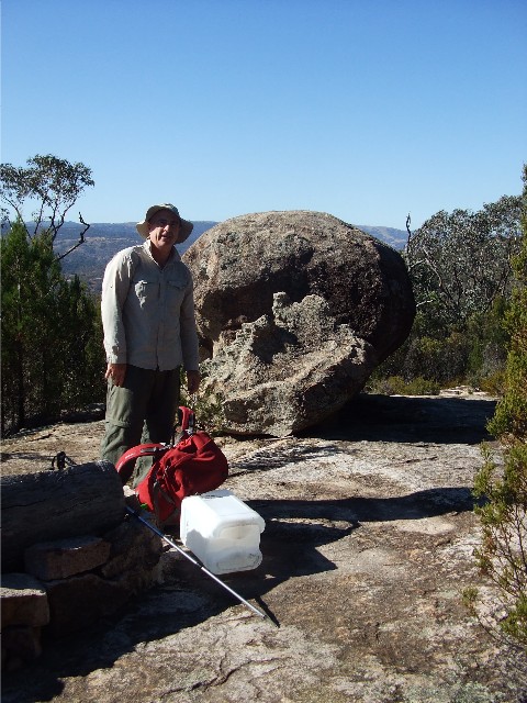
Sean Sunley at Cypress Pine Lookout
After 45 minutes we arrived at Cypress Pine Lookout. The spot is on an open rock slab dominated by a large round marble-like boulder and has impressive views back down to the Namadgi Visitors Centre and across the southern suburbs of Canberra and its surrounding mountain ranges. Even Black Mountain Tower can be seen through today's smoke haze, caused by some hazard reduction burning being undertaken in the hills surrounding Tuggeranong. The rest of our group had patiently waited for us to arrive, sampled some of Sean's home-made Macadamia and Cherry slice and then sauntered off onto the next stage of the walk.
This next stage is the most difficult of the climb. After crossing the same dry creek a couple of times, via some low wooden bridges, the track suddenly goes into lung buster mode. Calves and thighs scream as the lactic acid builds up and lungs scream for more oxygen as the track ascends steeply via stone steps through the forest. We pass small rock monoliths on the track side as the trail suddenly levels out and as you come around the next bend, are faced with another steep climb. I looked back at Craig as he turned another bend behind me to be faced with a steeper set of steps. The look on his face said it all. I had offered Craig one of my Leki trekking poles to see if they would assist him and Craig found that using a pole helped greatly, but it was dodgy knees that were slowing him down. With that I could sympathise as my knees also affect what I can do when hiking. I was quite content to walk a slower pace, stopping many times to enjoy glimpses of views through the trees - something I would do for the remainder of the walk. We had crossed an open rock platform which had given us excellent views of the Tinderries with their twin peaks over to the south east, but the steps continued on.
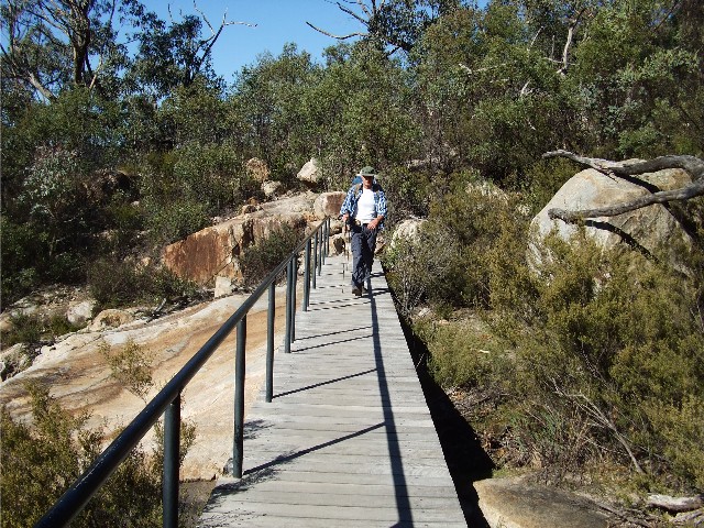
Craig crossing one of the small bridges during the ascent
Eventually the ascent levelled out, the temperature had dropped considerably and the vegetation had suddenly changed from dry sclerophyll eucalypt forest to sub alpine and then suddenly we had arrived at a track junction. Sean noted that the track to the right would be the one we would be walking out on to this point tomorrow. We had a short break before following the others to the summit. The track now becomes a fire trail which ascends gradually to a grassy saddle. It was along here that we were alerted to the presence of a large wombat. A rare sight at this stage of the day. This normally nocturnal animal was seen just 20 metres into the foliage from the track enjoying and afternoon meal. Too hard to get a decent photograph we still stopped to watch for a minute before carrying on.
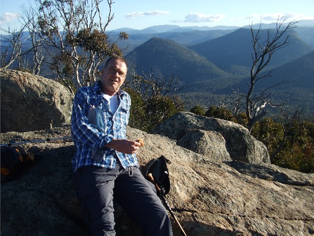
Craig takes a rest break on the summit of Mt Tennant with the Australian Alps to the south behind him
We now dropped our rucksacks on a grassy embankment at the junction of another fire trail only a short distance from the last intersection. We would be heading south from here, but now we put on our day packs or bum bags for the short ascent to the summit to the south east. We are now on a hard open dirt road which ascends to the summit of Mt Tennant. Our other group pass us and inform us they'll carry on to camp. We negotiated a tight hairpin bend and noticed the towers between the trees, we had arrived at the summit. The area is dominated by a large telecommunications tower, a fire spotters tower (with trig) and a large rock tor that gives us some spectacular views to the southwest. I'm still a newcomer to this area so naming the peaks before me can be more difficult than if I was in the Budawangs, but I know that among the landmarks there was Deadmans Hill, Booroomba Rocks, Bimberi Mountain, Mt Gingera, Blue Gum Hill and the Brindabellas. Even Sean was only able to name a couple. It had taken about 3 hours to get here from Cypress Pine Lookout. We wasted little time heading back to our rucksacks, collecting extra drinking water from the tank at the summit. We got back to our rucksacks at about 4.15pm and set off for the last stretch of trail to Bushfold Flats.
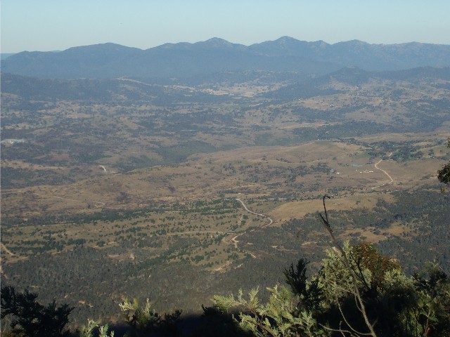
A view of the Tinderries with their twin peaks to the east as seen from the summit of Mt Tennant
We had some descending on an unsealed dirt road from here to the grassy plain at Bushfold Flats but it certainly took much longer than I originally anticipated. With the steep ascending now behind us, Craig was looking forward to some easier walking, but found that the descending was harder on his knees. He wasn't looking forward to the steep descent off the mountain tomorrow. We passed what could only be a feral pig and wild dog trap, a large cage on the side of the road. A nearby sign informed us of 1080 bait nearby. The only animals we saw though were numerous wallabies on the roadside, startling them as we came round a bend or over a small crest. They appeared to be large wallabies with a bushy end on their tails, possibly a red neckedÝ or rock wallaby.
We continued on still descending and came to a bend that looked like it had a side track. It wasn't. By now Sean had forged a little ahead while I stayed back to give moral support to Craig. Considering it had been 25 years he had done magnificently well to get this far, though in hindsight even he thinks he should have tried something a little less strenuous. Craig admitted he wanted to see where he stood as far as doing multi day walks go. He would leave his decision on that until tomorrow.
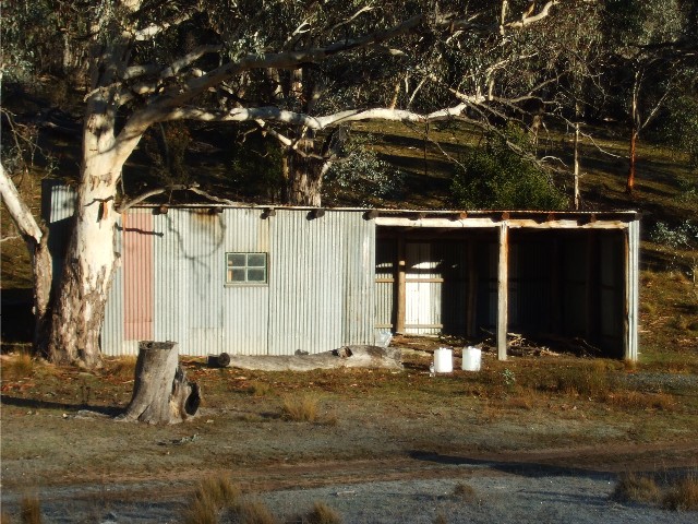
Bushfold Flats Hut
Within minutes we came to a signposted track junction and turned right, Light was failing rapidly now. The sun had gone behind the western ridges ages ago and only basic light was left. We passed another gate and just 100 metres beyond that was Bushfold Flats Hut. We arrived at 5.30pm with the last vestiges of light left. Of course, all the prime camping spots were taken though next morning the light revealed many wonderful spots. Craig and I walked into the field and up a small hill. The ground was littered with fresh and dry kangaroo poop, but we found two level spots near the top and spent the next 15 minutes putting up our tents and arranging bedding.
Craig and I both had our Macpac Microlights, one person tents that are very light in weight but very easy to pitch. They are excellent in all weather and very sturdy. With the practice of a multi day hike you can get one of these up in less than 5 minutes and in the dark we took just a little longer than that. Within the 15 minutes we had both tents up, sleeping mats inflated, sleeping bags unpacked and rucksacks emptied and contents placed in both tents. We now carried our stoves and food to the hut to cook our dinner.
Bushfold Flats Hut, is sometimes known as Bushfold Hut, Reads Hut or Dr Pearsons Hut and the original was built in 1884 by the McKeahnie family. The hut has been rebuilt several times, most recently in 2004 after the previous hut was damaged in the 2003 bushfires and had to be demolished. The hut is now built from wood and the remains of the previous hut's corrugated iron and built on a concrete slab. It has an iron fireplace but little in the way of furniture. The hut is a two room structure with a single enclosed room and an adjacent three sided machinery shed. There are remnants of an old sheep pen and animal holding yard adjacent to the hut. Sean had organised two large containers of fresh water to be delivered to the hut by National Park rangers during the week as there is little reliable water here. Sean and another would be carrying the containers back out tomorrow.
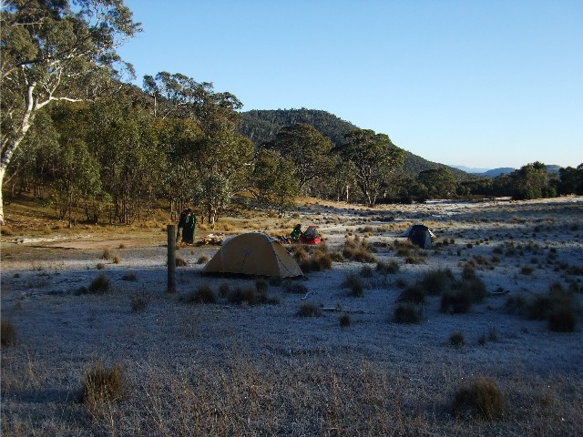
The view looking north from the early morning frosty campsite at Bushfolds Flat
Craig and I busied ourselves by our torch lights in cooking our meals. Craig had sausages which were cooked on my mini Trangia I had lent him, using the teflon frypan. He had carried in several bread rolls with which to eat the sausages. Craig always had been a hiking gourmet in the old days, amazing us with the array of different foods he would bring out of that Macpac Torre ruckasack. The freeze-dry meal and cup-a-soup I had given him remained untouched. For me, I was quite happy to munch on a couple of oat bars as an appetiser prior to boiling water for first my cup-a-soup and then my freeze-dry meal on my new Optimus gas stove which can amazingly boil a litre of cold water in less than one minute (where's the fun in that when you want to sit, chat and relax while your water boils?) The hot cup of tea was welcome, the soup was tasty as always but the freeze-dry meal was quite a disappointment. Back Country Chana Marsala - it was all chick peas, rice and an indian curry sauce that I found rather tasteless and very disappointing. I do try each new meal when they are released by Back Country and other brands and there are some excellent meals on the Back Country menu, but I think I'll give this one a miss in future. Others may disagree with this.
During the cooking Craig had forgotten his bush knife to cut open his sausages so I offered to head back to our tents to retrieve it and some matches (the Trangia is much easier and safer to light with matches than a cigarette lighter) Outside the temperature had dropped considerably, but we had a clear starry night sky above us. As I approached the tents I noticed both had become covered in dew which was now in the process of freezing in the cold still night air. I returned to the hut and after dinner we sat around talking until 8.30pm. Craig and I retired to our tents hoping we would be warm enough in our sleeping bags tonight. We were.
Next morning I awoke at 7.00am to a clear blue sky. The sun had not risen over the ridge yet and as soon as I unzipped my sleeping bag I felt the cold. Trying to change out of thermal sleeping wear and into hiking clothes in the small confines of a Macpac Microlight tent while trying not to push the inner tent against the wet outer fly is not easy, but I had no reason to worry about that as once I exited the tent I found the entire outer tent covered in frozen ice. The normally green hillside we had camped on was white with frost, but there was a hive of activity down at the hut 100 metres away. Craig was also up and we gathered our food bags and stoves and made our way to the hut to have breakfast.
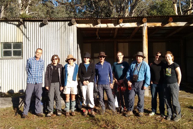
The Sub 24 Hour Bushwalking group for the weekend of 16th & 17th May 2015 - Photo: S. Sunley
The billy was boiled for coffee and a variety of breakfast cereals were eaten before packing up. Looking out the hut door the rising sun still hadn't touched any of the tents. It looked like we would be packing away frozen or soaking wet shelters this morning. I decided to wait as long as possible. As we had arrived in the last vestiges of light yesterday we hadn't had a chance to look at the surrounding countryside so Craig and I had a look around. If we had pitched our tents 100 metres to the north next to the track our tents would now be catching the warm sun, but we were not to know that last night. To the west were the impressive hills that included Booroomba Rocks, a side track on the AAWT well worth visiting for its impressive views of Canberra. The woods and grasslands behind the hut were also getting bright sunshine, but no tent could be pitched on their steep slopes.
By 8.15am the sun had finally hit our tents and while we packed up all our sleeping and cooking gear into our rucksacks we hoped the tents, now soaked with melting ice, would dry. Sadly this was not the case with only 50% of the tents drying. We had no choice but to pack the wet tents up and strap them to the outside of our rucksacks. At 8.45am we were called back to the hut to be included in group photographs.
At 9.00am we put on our rucksacks and joined Sean for the walk out. Most of the others had already set off and were vanishing into the distance. We followed the AAWT northwards through Bushfold Flats. The fields were filled with large mobs of Eastern Grey Kangaroos and the surrounding countryside looked magnificent. The old vehicle track passed high impressive ridges. Craig seemed to have gained a second wind this morning and had broken away to almost catch up with the rear guard of the faster walkers. He certainly felt that this walk had provided him with what he wanted to know - that he could again competently participate in multi day hiking trips, though perhaps not as steep as what we did yesterday and certainly at this point, no more than two day hikes. We discussed this as I caught up to him. His joining me for next month's Budawangs was definitely out, but he did think that joining in on Sean's next sub 24 walk in October was viable. The big worry now was how the descend would be handled with his dodgy knee.
A view of Booroomba Rocks as seen from the trail just as we leave Bushfold Flats
For now the track followed the old vehicular track north until we reached a point where the trail appeared to veer to the left. A much fainter track continued straight ahead before narrowing into a foot track and veering to the right and disappearing into the woods. The track from here is not shown on the topographic map, though it is signposted and is shown on the map of the area in the Chapman/Siseman book on the Australian Alps Walking Track - care was needed as some early sections were not obvious, though we soon regained a well defined track. This narrow bush track ascended gradually through the forest and was quite pleasant walking. We crossed a dry creek and continued upwards until the track levelled out and before we realised it we were at the track junction we had stopped at yesterday prior to our side trip to Mt Tennant.
Sean, Craig and I decided to relax for ten minutes and enjoy the last serenity of the mountains before our descent. It was 10.30am when we commenced our descent. The going was slow and tedious, the many steps causing much strain on our knees and I hate to think how harder it would have been without the help of our trekking poles. Being a Sunday morning there was almost a log jam of people on the track this morning and they ranged from families on a day out to day hikers wishing to bag another ACT peak, to the super-fit and obvious lunatic joggers running up the mountainside. There were some who had decided to walk just part of the way, intending to increase their journey by another section next time they came out here. The air was now quite warm as the sun blazed down on the track. The birdsong was drowned out by the incessant whine and drone of the model airplanes flying around below. We again stopped at Cypress Pine Lookout for another 5 minute breather and polished off the last of Sean's excellent macadamia and cherry slice, then it was on downwards, much easier now as the descend levelled off. We crossed the Naas Road and walked the last few hundred metres to the visitors centre, arriving at exactly 12.30pm.
There was still a handful of our group there to greet us, three of them were passengers in Sean's car but they gave Craig a hearty "Well done" for his first effort in 25 years. Then everyone else drove off leaving Craig and I to load our rucksacks back into my Rav4 where I remembered the ice cold beers sitting in the car esky. A nice way to finish off a tough but enjoyable weekend out in the mountains.