Maps - Tasmap Cradle Mtn - Lake St Clair National Park
CREW - Nathan (Guide), James (Guide), Paul Ellis, Karen, Jenny, Barry and Bill
DAY 1 (Saturday 12th March 2005)
Saturday 12th March 2005 was a clear sunny day in Launceston Tasmania as I made my way to the Paddy Pallin Adventure Store in George Street for the 1.00pm meeting. I was the 2nd of my group to arrive and I was shown to an open area near the back of the shop where I met Bill, a Queensland Policeman, the first of 5 walkers going on this trip. Soon after, Karen and Jenny arrived, two Queensland health workers and not long after that arrived Barry, a farmer from Western Victoria. We were then introduced to Nathan and James, our guides for the next 8 days.
First on the agenda was a very thorough gear check. We were asked to fully unpack our rucksacks, then one of the guides would check off our gear on the checklist, to make certain we had everything required and that it was up to standard for the Overland Track. I now knew how some of my friends felt prior to some of our multi-day walks when I would check their gear. Thankfully, my gear passed the test with the only query being made on the garbage bag liners I was using in my rucksack. These were accepted only because I had double-lined my pack. Some of my fellow walkers though, were required to hire extra gear, but they had expected this, and for a small fee, several rucksacks and sleeping bags were replaced. Our guides then gave us a quick briefing on what we can expect over the next 8 days.
At 1.50pm our shuttle bus arrived outside and we made our way to the bus, put our gear in the trailer and boarded the bus for the drive to Cradle Valley. Our driver was Andrew who would be driving us in to Cradle, then pick us up from Lake St Clair at the end of the trip. We had one stopover during the journey, at Sheffield, Nathan's home town and known as 'The Town Of Murals' due to the number of excellent paintings on the sides of many of the buildings. Here we had our last chance to purchase a snack. I also purchased a packet of cigarettes after discovering that our lead guide, Nathan was a smoker. I felt very much surprised at this as normally, a smoking bushwalker is generally frowned upon. I was to be further amazed by the amount of cigarette smokers I would come across during the course of the Overland Track - walkers, guides and rangers.
With the 30 minute break over we continued our journey into the mountains and at 4.30pm we arrived at the Cradle Valley Visitor's Centre where we got out and had a look around while Nathan organised our cabin keys. In the visitor's centre was a 3D model of the Cradle Mountain area showing the mountains, hills and tracks, many of them very steep. Bill wryly commented "Can we go home now?" after seeing the steep track up Marions Lookout. Then it was back to the mini bus for the short drive to the cabin. We arrived at 4.55pm. The cabins are located just behind the reconstructed Waldhein Chalet, originally built by Gustav Weindorfer who originally settled in and explored the Cradle Mountain area and was responsible for turning this area into a National Park. The cabin had 6 bunks, a kitchen, eating area and a wood stove. A communal toilet block could be found outside. Once we had dropped off our gear we were encouraged to go outside and explore while our guides prepared our dinner.
We quickly made our way to the chalet to look around and check out Gustav Weindorfer's grave site, take a look at the views from the road and hopefully spot a few wild animals. I was lucky enough to see a wombat and a Pademelon (a small kangaroo) during the next hour. I also took the short walk through Weindorfer's Forest Walk which was only a short 10 minute stroll through the forest behind the chalet. This circuit walk took me through a very rare forest of King Billy Pines 1000's of years old, all with rich coverings of moss around their base. I noticed also that the weather had changed. It was now quite overcast and we did get a light shower of rain. At 5.30pm we were summoned back to the cabin for a light pre-dinner snack of Tasmanian cheese crackers and dip and to prepare our bedding for the night.
At 7.30pm we were served our dinner. Garlic Bread, Pasta with chicken & veggies followed by fruit salad for dessert. The food was plentiful and most of us could not finish our meals. With dinner finished Nathan and James provided the bushwalking novices with a rucksack packing lesson before showing us the entire Overland Track route on a map and giving us a further briefing on what to expect during the next 7 days of walking. Our guides would be sleeping in a separate cabin and warned us of the local possum problem, informing us of the importance of locking the door as the possums had learned how to open the cabin doors and raid the food supplies. No sooner had this been mentioned than there was a commotion outside the door which revealed itself to be a rather large possum. Our guides also informed us there would be another group walking along for the first half of the trip. These were a party of professional photographers (who had their own guides) and we were informed we may just become photo subjects over the next few days. With a big day ahead of us tomorrow we all decided to hit the bunks by 9.00pm.
DAY 2 (Sunday 13th March 2005)
We were all up by 7.15am, keen to start walking. First though was breakfast which was last night's uneaten fruit salad with yoghurt. Our guides handed us our food bags which to our surprise were rather small and light compared to what they were carrying. We were also asked to prepare our lunch for today. We had a selection of bread rolls, salad, varied meats and cheese. We were also informed to pack a selection of fruit and muesli bars for the trip. The fruit would have to last, though everything else would be supplied from a selection of food drops on the track.
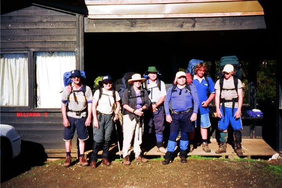
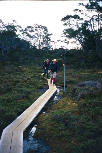
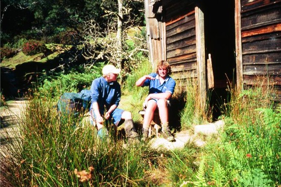
Our intrepid group prepares to leave our overnight hut and set off along
the Overland Track
L-R: Barry, Jenny, Karen, Bill, Paul & our guides Nathan &
James
Outside it is another clear sunny day, though the early morning temperature was quite chilly. We packed our rucksacks and at 9.35am, after group photographs were taken, we headed off. Behind the cabins was an access track, boardwalked as it descends through the buttongrass plain. We could see the tourist cars parked at Ronny Creek car park below us. The track crossed Ronny Creek then, passing the intersection to the Horse Track (a less than scenic alternative to Kitchen Hut) we then started ascending alongside the creek and though forest until we arrived at Crater Falls and took the opportunity to catch our breaths. So far I noticed that Barry seemed to be the fittest of us all, he hardly looked like he was breathing heavily. We had a decent rest at Crater Falls to admire them. They were only about 7 metres high but cascaded below to Ronny Creek for some distance. We all took the opportunity to take photographs, even though we knew there would be better waterfalls to photograph later on.
At 10.20am we continued on, ascending steeply above the falls to Crater Lake. It was now becoming quite warm and we were all stopping for quick breathers. It was 20 minutes later that we arrived at Crater Lake and Weindorfers Boat shed. The water was so clear we could easily see the small fish in the water and they were quite abundant. At the far end the valley rose steeply to Marions Lookout. At 11.10 we continued on to Marions. A short ascent took us to a spot where we had views down to Lake Lilla, but it was the climb above to the rocky bluff of Marions Lookout that took our attention. This climb was very steep and our guides informed us of the section of chain we would have to use at the steepest section. We were not looking forward to the climb.
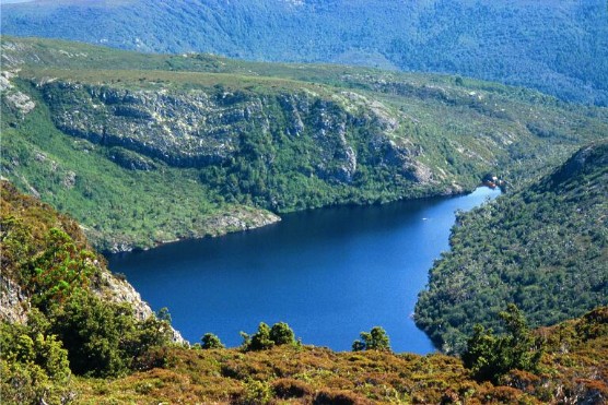
Crater Lake from Marions Lookout
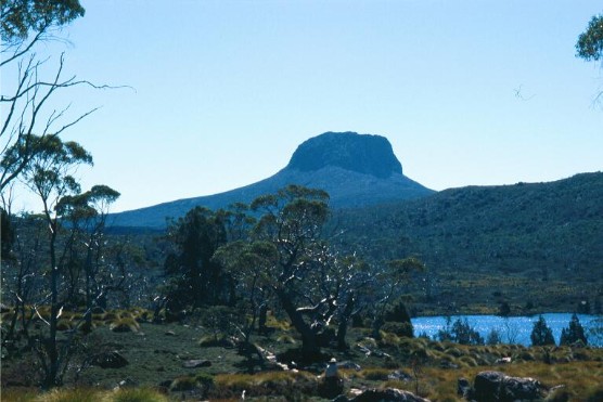
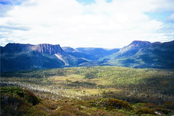
In the end though it wasn't too bad. We followed the route steeply through scrub and rock up to the chain section, but I found the length of chain actually helped and I was starting to enjoy myself despite the fact my lungs were bursting. Finally at 11.30 I arrived up onto Marions Lookout to the first magnificent views of the Overland Track. Under a clear blue sky ahead was the impressive walls of Cradle Mountain while below us was the blue expanse of Dove Lake. Our guides informed us that you get clear weather on Cradle Mountain only 37 days of the year. This was one of them and I felt privileged. We stood or sat there for some time admiring the scenery and taking photographs before moving on to our lunch spot at Kitchen Hut.
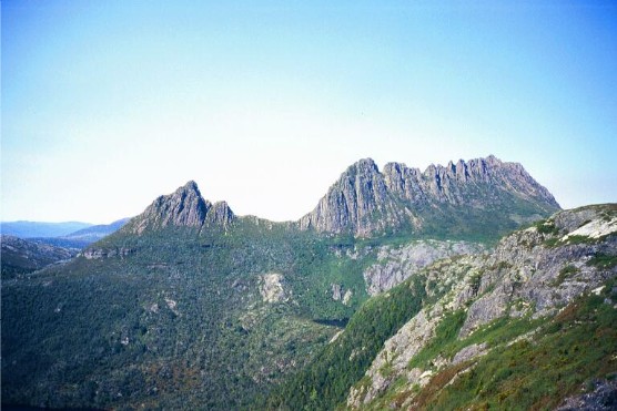
Cradle Mountain on a clear sunny day. Taken from Marions Lookout
The track now undulated across Cradle Plateau. The track a mixture of gravel and old boardwalks with constant views of Cradle Mountain and our first views of Barn Bluff. The low vegetation was dominated by Buttongrass and Cushion Plants and there were Tarns everywhere. We had been warned by our guides about the sensitivity of the Cushion Plants. Bright green, they're actually hundreds of smaller plants that have formed a colony that below the surface, keeps a regular temperature of just 17 degrees celsius. We were told not to step on these or any of the other plants in this fragile area at any time.
We arrived at Kitchen Hut at 12.20 and stopped for lunch. The area outside the hut was crowded with walkers, as is expected on such a perfect day of weather. Kitchen Hut is a small two storey structure and is not used for camping except in the case of emergency. Outside the top floor door is a shovel. This is used during winter to dig your way out, that's how high the snow gets here. Nathan & James were hoping we would see some of the Quolls that live close to the hut - they have become quite tame, but alas we were not that lucky, too many people about. We enjoyed our lunch with views up the side of Cradle Mountain, watching groups of walkers heading off to climb to the summit. We watched them ascending the steep track and following the rocky traverse before disappearing into the distance. I wondered how in the hell I was going to manage this climb as I foolishly puffed on a cigarette.
At 1.05pm Barry, James and I stowed our packs inside Kitchen Hut and made our way up the track to climb Cradle Mountain. Nathan would take Karen, Jenny and Bill to our campsite at Waterfall Valley where we would meet up with them later. Jenny declared she was quite happy to have seen Cradle Mountain rather than do the climb. At times during the next hour I wished I had taken her line of thinking.
The open track ascent to the traverse was steep and made the climb to Marions Lookout pale in comparison. Barry practically flew up the track, this western Victorian farmer certainly had the fitness to do the climb effortlessly and I envied him. However, I grimly battled on while he and James patiently waited for me to catch up at each section. I was greatly relieved when I reached the traverse, but worse was in store. We soon found ourselves climbing over boulders as we ascended towards the top. This was very slow going and the route up was marked with steel stakes placed at intervals. Many times during the ascent I felt like turning around and going back but only the thought of missing out on the summit on a day of perfect weather kept me going. I passed many people who had decided that they would go no further today. The heat and effort of climbing had taken away their enthusiasm for the climb and I knew how they felt. Near the top I was depressed to find the route now descended to a small valley before climbing again, but by now I had come too close to the summit to turn back. James the guide kept stating we needed to be at the summit by 3.00pm to gives us the necessary time to return to our packs and get to Waterfall Valley and I now felt I was being rushed, but I kept battling along. Eventually, at 2.40pm we reached the summit.
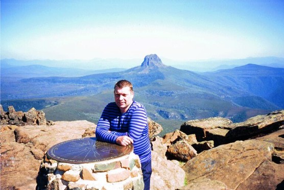
Paul on the summit of Cradle Mountain with Barn Bluff in the background
The summit was marked with a bronze plaque which names all the surrounding peaks. The views were brilliant with Barn Bluff dominating. In the distance we could make out Mount Ossa (Tasmania's highest mountain) and the surrounding peaks - Mount Pelion West, Mount Oakleigh, The Ducane Range etc. At 3.00pm after a short rest we made our descent back to Kitchen Hut. I was not looking forward to the descent, sometimes I find it much harder than climbing, but I was quite surprised how easy it became and by 3.50pm we were back shouldering our packs at Kitchen Hut.
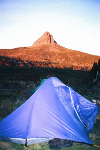
We now followed the Overland Track around the western face of Cradle Mountain, stopping at a creek to stock up our water near the views down Fury Gorge. We now ascended gradually along the track for a short distance before once again following boardwalks with Barn Bluff ahead of us in full view. We turned left at the track intersection to Barn Bluff and descended through a forest of Pandanni Plants (the world's tallest Heath) towards Waterfall Valley. We arrived at Waterfall Valley at 5.55pm, passing the now full Waterfall Valley Hut and the helipad now being used by walkers as a cooking platform and strolled down to Old Waterfall Valley Hut, next to which was the rest of our party all relaxing by their tents. The photographers all had their gear out and were busy taking shots of the scenery. I picked myself a spot with a view of Barn Bluff dominating and pitched my tent, the ground was a little uneven, but it did not turn out to be a big problem.
I was starting to feel a little sick - obviously the day's activities in the sun had left me with a mild bout of heat stress so I lay down in my tent for a short time until dinner was called at 7.45pm. Our guides had selected a spot across the creek from the old hut next to a small waterfall and we gathered there for our meal. We soon became aware of a small boy nearby who had started to announce his presence to everyone. The young boy's name was William and he became a bit of a pest to us. Bill (our Queensland Police Officer) was not slow in teasing the young boy, especially about his choice of pyjamas (a set of very colourful thermal clothing). Young William was in and out of our cooking area all evening, even getting the guides to allow him to toast his marshmallows over the stove, until his parents called him in to bed, much to our relief. Dinner turned out to be Spaghetti Bolognaise (or as we were to call it) Skippy Bolognaise as the meat used turned out to be Wallaby Mince. My heat stress had affected my hunger and although I knew I had to eat something and the meal was quite tasty, I hardly got through half my meal. The others all enjoyed strawberry pavlova with cream while I decided to take an early night, retiring to my tent at 8.30pm.
DAY 3 (Monday 14th March 2005)
I woke up at 1.15am needing to make a nature call, but I couldn't find my head torch. I remembered I had placed it on top of my toilet roll in the corner of my tent near the top of my sleeping bag. In the dark I just couldn't find it. I got myself out of my sleeping bag and exited the tent, then started a thorough search for my torch. I eventually found it had somehow got into my sleeping bag and had made it's way down to the bottom of the bag. Thankful for small mercies I made my way along the track to the toilet building. In the dark I could just make out Barn Bluff, silhouetted black against the clear night sky. The toilet building is two storey. You climb the staircase to the top floor and enter the toilet which is a 'Pit - composting toilet'. Your waste drops to the container on the floor below and when finished you add a cup of sawdust (or rice husks) provided in a barrel to the pit before closing the lid. One smell I will always remember from this trip is the combined smell of human waste mixed with sawdust. Unfortunately not everyone was closing the toilet lid when they finished and this made the smell much worse. I returned to my tent and slept until 7.00am.
My campsite on the morning of day 2 at Waterfall Valley
with Barn Bluff as a backdrop
Today was another clear sunny day. The photographers were out early taking shots of the early morning colours of Barn Bluff. I joined the rest of the walking party at our makeshift kitchen for breakfast, feeling much better this morning after a good night's sleep. Breakfast was porridge mixed with muesli and honey, plus a cup of tea. Young William was also up early and wasted little time in joining us amid threats to have him hung by his ankles from the nearest tree. A walk along the trail towards the toilet block area revealed a bird I had never seen before. It was obviously flightless and was noticed moving around through the buttongrass. It turned out to be a Tasmanian Native Hen. This bird had been given a name by the Tasmanian Expedition guides who called it the Turbo Chicken. Why? Just try to catch one, they move like lightning.
By 9.30am we were all packed up and ready to go. Already the weather was warming up. It was going to be another hot sunny day. I was happy this was going to be a short walk to Windermere Hut. Just 7km of walking trail. We headed off at 9.45am and were soon back on the main trail. I was surprised we were not going to take a look at the many waterfalls of Waterfall Valley, but I later learned from our guides that after months of dry weather there wasn't much water coming into the valley, also, the rangers were trying to stop people going down to the falls as the high number of people traffic was causing much erosion to the area. As we moved off south along the Overland Track we heard the sound of a helicopter coming in to land at Waterfall Valley. We were informed the chopper was picking up a sick walker.
We followed the trail as it ascended out of Waterfall Valley. We followed the edge of a cliff for a short distance. Behind us were views of Barn Bluff, Cradle Mountain and Mount Emmett. We were now crossing open moorland with views of the main range in front of us. At 11.00am we arrived at a track intersection and stopped for a break. In front of us was picturesque Lake Holmes which was surrounded by a thin stand of Pencil Pines. The track at the intersection led to Lake Will, a 30 minute return walk. With the arrival of guide Nathan, who had paid a visit to one of the guide's food drops we now moved on towards Lake Windermere. Personally I was disappointed at not getting the chance to visit Lake Will (Oh well, next time). We now cross the high moorlands, getting glances across to the Eldon Ranges. At the top of the next rise we saw our first glimpse of Lake Windermere, a large picturesque lake, complete with a group of small islands in the middle. We now descended to the lake and followed the shoreline for some distance until we reached Windermere Hut and the camping area at 1.15pm.
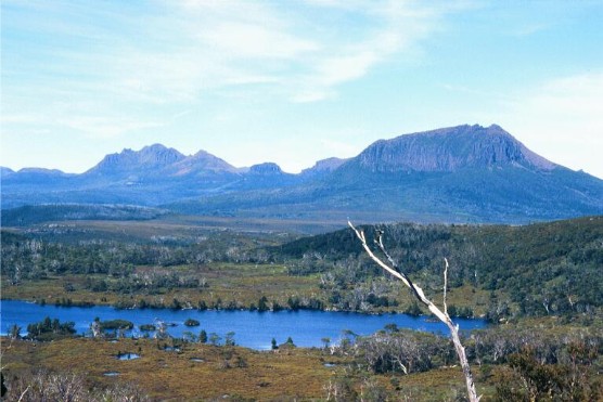
Our first glimpse of Lake Windermere with Mount Pelion West and Mount Ossa as the backdrop
Bill and Barry on the track to Lake Windermere - Cradle Mountain barely visible through the trees
The guides immediately prepared our lunch. This was Burrito Tortillas with salami, cheese, tuna and salad. This meal was to be our regular lunch for the remainder of the trip and it became my favourite. So much so that upon returning home and doing the weekly shopping, Burrito Tortillas quickly became a regular item on the shopping list. We then had the fun of pitching our tents on the new tent platforms, a job that for me became a nightmare. My one man tent just didn't seem to be made for pitching on these platforms. It certainly looked easier for my companions who had 2 man tents. However, after several tries I finally got my tent pitched. The tent platforms had great views across Lake Windermere to Barn Bluff.
Barn Bluff and Lake Windermere from our tent platforms at Windermere Camp
At 3.30pm we were all encouraged to walk back down to the lakeside to take a swim in the lake. I wasn't too keen as I felt I was developing a nasty head cold, but decided it was a good way to get a wash and clean my clothes. We all went in and the water was freezing but invigorating. Barry, not content for just a dip, swam across to the nearest island, much to the amazement of the rest of the walking party and the other hikers who had gathered. We returned to camp at 4.15 for our afternoon cuppa. By now my cold had got worse and I was given some cold & flu caps from the guide's first aid kit. We sat around the guide's tent platform for the rest of the afternoon talking. The guide's platform was also utilised as our kitchen as well as their sleeping area. I was quite surprised to learn they slept under a tarp rather than using a tent. I hoped their sleeping bags kept them warm.
Dinner tonight was a very hot Thai curry that had some of my group dashing for the water bottles. Today was also Jenny's birthday and she was surprised with a special cake made by the guides, complete with sparklers. We also crossed paths with young William again, he just couldn't keep away, we tried everything including warning him about 'Drop Bears' and the very dangerous 'Kangawallafox'. Young William thought we were joking, but one look at Bill's serious poker face convinced him otherwise. We also became aware of the playfull stirring that goes on between the guides. Young James, who was with our party was informed by some other campers that two of the guides with the photographers had placed a rather large rock in the bottom of his rucksack, as well as a large bag of rubbish. James and Nathan declared revenge would be swift and we sat around discussing the best way to get revenge at New Pelion Hut tomorrow night as the photography group would be leaving the Overland Track via the Arm River Track the day after. We had only one night in which to put our plan into operation. We moved back to our tents at 8.15pm.
I'd no sooner got into my sleeping bag than there was an enormous commotion outside. The local possum population had raided the campsites and were sneaking into some of the open tents. Much cursing and swearing and the sounds of fists thumping the sides of tents continued for quite some time. I could hear the patter of possum feet as they made their way past my tent, but soon enough the noise ceased and we were able to get some sleep.
DAY 4 (Tuesday 15th March 2005)
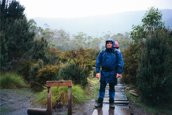
I was up at 7.00am. My head cold had taken hold and I'd had trouble breathing in my sleep. It had been quite a restless night. Everyone was talking about the possum problem last night. We had a quick breakfast and packed up. It was quite overcast, we had expected it, for the forecast had been for rain from Tuesday to Thursday. We copped a very light shower whilst packing up, but nothing more than a few minutes. At 8.50am we set off south for Pelion Plains, a walk, our guides informed us, that would be as long as the first day. Our guides were still packing and sent us on ahead with instructions to wait at the top of the first big hill.
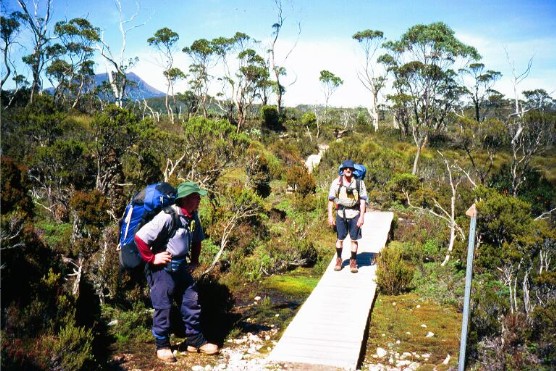
Karen and Jenny walking the boards just south of Windermere Hut
So off we went, following the boardwalk through light forest and then open buttongrass plains, giving us some minor views of Lake Curran. It was overcast, cold and windy, but the walking soon warmed us up. It was an undulating track, mostly boardwalk, but in several sections just gravel. Occasionally on the rise we would get views of a shrouded Mount Oakleigh and Mount Ossa, and closer, of Mount Pelion West. I set myself a steady pace and soon found myself out in front. Obviously my companions had stopped to take photographs. For much of the way you could see the track winding far into the distance and knew exactly where you were going to walk. I waited at the top of the main ridge for everyone, including the guides, to catch up, which wasn't too long.
We now crossed Pine Forest Moor. Wild and windy, but providing great views, especially of Mount Pelion West. The track markers, metal stakes, were covered in mosses and occasionally we would pass the gnarled skeletal remains of a pine tree. There were several small tarns here and in better weather would give excellent reflections of Pelion West - a photographer's delight. At 10.20 we took a short side track to have morning tea at the Forth Valley Lookout. Despite the foul weather, the views were magnificent. This valley was originally carved out by a glacier. Behind us we could still make out the familiar sights of Barn Bluff and Cradle Mountain.
Mount Pelion West reflected in a tarn on Pine Forest Moor
We continued on, now making our way through a thick forest. The track here was badly deteriorated, the boardwalks and gravel now making way for tree roots and rocks and the occasional mud puddle. Tin tag markers nailed to trees gave me the only joy of knowing I was still on the right track. Once again I had forged ahead of my companions. The forest was mainly pine but one section of the forest was growing back, the skeletal white forms of long dead trees were abundant here. The walk now descended through a thick stand of rainforest, with Pandanni plants dominating. Suddenly I was again walking across moorland and on boardwalks.
The rain came just as we descended to Pelion Creek. We stopped here for another short break before the long descent to Frog Flats. The walk was quite an obstacle course, tree roots, rocks, thick mud and badly damaged boardwalks. The rain got heavier as I stepped out onto Frog Flats, the lowest point on the Overland Track. A quick photo with the signpost, then it was on to lunch, not far away where the footbridge crossed the Forth River. Our guides had set up the tarpaulin over a large dead fallen tree trunk and with the photographer's party both groups attempted to enjoy their lunch break in the rain.
Paul in the rain at Frog Flats - the lowest part of the Overland Track
At 2.30pm we continued on again and the last section to Pelion Plains. It was all mostly uphill through thick forest. I hadn't gone too far when the rain stopped. It was time to discard the wet weather gear and continue on. Again the track was very muddy and the walking was made harder being an uphill slog. Eventually the track levelled out, but the muddy conditions continued. Finally I came to an open grassy plain. This was Pelion Plains, but there was no sign of Mount Oakleigh, it was totally covered in thick mist. At 3.00pm I arrived at the campground just above New Pelion Hut, the most modern of the huts on the Overland Track. I now learned why we had not been utilising the huts on the Overland Track. All walkers who are part of touring groups, such as Tasmanian Expeditions, have an agreement not to use the huts for sleeping. I thought this was a bit of a crock, but had no choice but to accept this. However, we were allowed to utilise the huts for shelter until night time.
The only tent platform was already crowded, so I pitched my tent on the grass, just as the rain came down again. I quickly got my tent up, unpacked the rest of my gear, then walked down to the new hut to dry off and have afternoon tea. I was soon joined by the rest of my group who had pitched nearby. It soon became obvious that we had pitched out tents in Leech City as a rather bloated leech dropped off Barry's leg and onto the outside deck of New Pelion Hut. Everyone quickly checked themselves for leeches. With the rain continuing to pour down we explored the hut. A modern recently built structure that can accommodate up to 60 people and the biggest of the huts on the track. This afternoon it seemed that the hut had easily accomplished that number. Inside was a series of neat tables with shelves for cooking stoves. The sleeping areas were vast, with 6 bunks, some double in each room. The outside decking ran around the entire outside of the hut and was fully covered. Here all the guides set up their sleeping and cooking equipment and here would be the place we would have our dinner. The hut was also a haven for the local wildlife which often sheltered under the decking. During the afternoon we noticed possums and Bennetts Wallabies, but heard there were also Wombats, Quolls and Tasmanian Devils in the area.
Our guides have a hidden food dump only 10 minutes walk from New Pelion Hut and used the afternoon's inactivity to top up supplies. Tonight our dinner was another curry, though not as hot as light night's fare. Young William again made his presence felt, but as tomorrow would be our rest day and William's family would be moving on, this would be the last we would see of him - Hooray! Bill suggested a farewell photograph with young William for memories sake, with two of us holding him upside down by the ankles. Strangely, this opportunity never arose. The rain ceased for a short while so I used the opportunity at 8.00pm to return to my tent for the night.
DAY 5 (Wednesday 16th March 2005)
Up at 8.30am to an almost clear sky. I was amazed that despite the forecast, the weather was clearing. Today was the official rest day of the trip. We had been informed that we could spend the day lazing around camp, or take one of the side trips that was on offer. I hoped we would get a chance to visit Mount Oakleigh, but there were other people in our group who may want to go elsewhere. I decided to wait to see what happens. The photography group moved off, we would see no more of them for the remainder of the trip. We asked James & Nathan how the revenge went off the night before and were told the possums had a field day. With the other guides sleeping on the deck on the other side of the hut, James & Nathan had snuck around once the guides had got into their sleeping bags and deposited scroggin and biscuits all around the other guide's sleeping areas. They then returned to their sleeping area to listen to the noise and we were informed it was quite an eventful night. One up for James and Nathan.
We had a quick breakfast and after which, as the tent platform had now become vacant, we took the opportunity to move all our tents there. Once again the pitching of my tent on these monstrosities became a bit of a nightmare, but I eventually managed to get the tent up and secure. That is, after I removed all the leeches from the underside of tent floor. Apparently everyone else had leech trouble last night with the little bloodsuckers trying their best to get into all the tents. I was amazed how I got away with the leech problem at all.
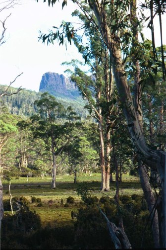
Looking across Pelion Plains to Mount Oakleigh from near New Pelion Hut
Above us came the strange call by a green parrot which we finally noticed sitting high in a nearby tree. It turned out to be a Tasmanian Rosella (Thankyou Brett), but it was the call that was distinctive, a very sharp rasping "Kussik Kussik" sound that annoyed the hell out of Bill, who spent much of the rest of the trip verbally abusing the parrots everytime he heard their call. The parrot's call was suddenly drowned out by the arrival of a helicopter which landed on the helipad just in front of the Hut. Dropping off a ranger on maintenance duty. We heard the chopper would be busy today, dropping off lumber at Kia Ora Hut for the building of more tent platforms and boardwalks. The delivering had already been done here at New Pelion Hut. Next to our tent platform was a very large supply of new timber.
We now had great views across Pelion Plains of the fluted Mount Oakleigh. A large climbable mountain with tall eroded columns at it's northern end. It became my most photographed mountain on the entire trip and I seem to remember commenting to my fellow walkers that it was easily my favourite mountain on the Overland Track. I was looking forward to climbing it this afternoon.
It wasn't until after lunch that it was decided where we would be going today, and to my disappointment it wasn't Mount Oakleigh. We would be back tracking to Old Pelion Hut and then visiting Douglas Creek where we would be able to do some washing and take a swim. We followed the track back towards Frog Flats for 10 minutes, then took the side track to Old Pelion Hut, a 15 minute walk across the buttongrass plain, memorable for the amount of deep mud. And I mean deep, one section was so deep it almost covered the entire length of my trekking pole. Worst still, our guides watched our every move, making sure we didn't step around the mud and step on the buttongrass mounds. Anyone who did was instantly ostracised. There was a huge difference between this hut and the new one, the old hut sleeps just 8 people and looks ready to fall apart. We then made the 5 minute walk to Douglas Creek, noticing the old miners bridge upstream from where we sat. Sadly the bridge was closed and guarded by a ranger so we couldn't cross or take photo's from the bridge. I took the opportunity to wash some of the clothes I had been wearing while Barry again confounded everyone by going for a swim in the frigid water.
We were soon joined by a group of 12 walkers. Judging by their fresh smell and clean clothes we deduced they were with the Cradle Mountain Huts, a group that utilises the private commercial huts along the track. These huts come complete with laundry facilities and hot showers and it didn't take long to learn that most walkers on the Overland Track treat these 'Hutties' with some contempt. Apart from one male guide, this group was all women, mostly aged from the early 30's to late 50's. A further surprise was when most of them went in for a swim, some of them topless despite the fact there were males close by. Our group decided it was a good time to return to our camp.
Back at New Pelion Hut we lazed around watching the new arrivals come in. There didn't seem to be as many as yesterday. In fact, by nightfall we estimated there was no more than 30 hikers using the hut that night. We found ourselves talking to another hiker who had been camping near us at all the huts so far during the trip. Like us he and his son had decided to stay at New Pelion Hut for two days and unlike us, had spend today climbing Mount Oakleigh. Ian and Billy were to cross our path many times before the trip ended. Our dinner tonight was Ratatouille. I retired to my tent at 8.30pm. Tonight was the coldest so far on the trip, made much worse by the fact the zip jammed on my sleeping bag.
DAY 6 (Thursday 17th March 2005)
We woke at 7.15am to ice on the tents, even the tent platform was slippery. It was freezing cold, the temperature gauge at New Pelion Hut read minus 8 degrees celsius. The Pelion Plains were white as if covered by snow, only the distant Barn Bluff and Cradle Mountain looked like they had sun. It was a clear sunny day and while we braved the morning chill eating our breakfast we watched as the sun crept across the plains, melting the ice as it came closer.
Packing up was quite a chore, the melting ice turned our tents soaking wet and they had to be hung over the nearby timber to dry. I took the opportunity with the extra drying time to unjam the zip on my sleeping bag, hopeful it wouldn't jam again.
At 9.55am we moved off, heading for Kia Ora Hut. We ascended through thick forest, the track following Douglas Creek for a short distance. We made one quick stop to check out some cascades on the creek, but the views were tree interrupted. We were ascending to Pelion Gap, the highest point on the Overland Track and the steep track was exhausting. Thanks to my head cold I was having trouble breathing, my nose was blocked and I was reduced to coughing fits. I was thankful I'd finished off my cigarettes yesterday, all I had left was rollies and I'm not that keen on them. The track wasn't too bad, but in places we still had sections of thick mud. Soon though the trail levelled out and at 11.30am we arrived at Pelion Gap and stopped for an early lunch.
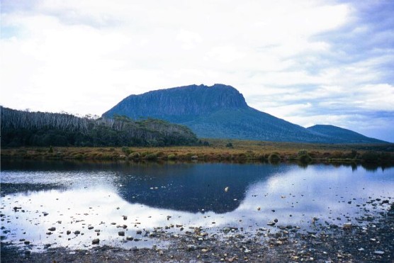
Pelion Gap has a large timbered floor area where walkers can sit or place their packs. There were a number of other walkers here, including the 'Hutties'. Pelion Gap provides magnificent views. To the south is Cathedral Mountain and the Ducane Range, to the north, from where we walked are the fluted cliffs of Mt Oakleigh with Barn Bluff and Cradle Mountain still in the distance, to the east is the Pigeonhouse-like Mt Pelion East and to the west behind Mt Doris, is Mt Ossa. These are among the best views from the Overland Track. In fact, my favourite view is looking down Pinestone Valley to Cathedral Mountain and the Ducane Range not far from here.
Looking down Pinestone Valley from Mt Doris with Cathedral Mountain on the left and the Ducane Range on the right
After lunch we all took the side track to Mt Doris for views down Pinestone Valley. From here we again split up into two groups. Karen, Jenny, Bill and James would return to Pelion Gap and our packs and head off for Kia Ora Camp. Barry, Nathan and I would make an attempt to climb Mount Ossa, Tasmania's highest mountain. We crossed the traverse near the top of Mt Doris, taking in the magnificent views down Pinestone Valley and watching as a helicopter delivered more materials to Kia Ora Hut. The track was quite rocky, but cushion plants and a number of small shrubs were abundant.
My head was throbbing and my breathing laboured and I soon fell behind my companions. I was starting to wish I'd stayed with the other group. When I caught up to Barry and Nathan at the bottom of the main climb I'd made up my mind that I would not be completing this climb. Ahead of us was a very steep ascent to the two towers near the top of Mount Ossa. I told my companions I would return to Pelion Gap and await their return as going with them, I would only slow them down. I watched envious as Barry and Nathan commenced the climb before heading back and descending to Pelion Gap. I arrived back there at 2.20pm and sat in the hot sun kicking myself for allowing this stupid head cold to get the better of me. Occasionally I had the company of other walkers, some of them also waiting while members of their walking party climbed Ossa, others taking a rest after finishing the climb. Their descriptions of the magnificent views from the top did nothing to alleviate my disappointment of not doing the climb.
At 4.20pm Nathan and Barry returned and after a 25 minute rest we shouldered our packs and set off down the track and the descent through another buttongrass plain to Pinestone Valley. The views of Mount Pelion East, Cathedral Mountain, Mount Ossa and the Ducane Range with us for most of the way. We stopped at a fast flowing creek to collect water and continued walking through light muddy forest.
We arrived at Kia Ora Hut at 6.00pm and joined the others, pitching our tents on more platforms. I could see why this site had become our guide's favourite campsite. From every vantage point we had views of the surrounding mountains. I had a great view of Mount Pelion East from my tent platform. Across the valley was Cathedral Mountain on one side and Mount Ossa on the other. Behind us was the Ducane Range and below was a fast running creek. The noise from the cascades quite relaxing. By now I had got the hang of pitching my tent on the platforms and once my tent was up I joined the others in exploring the area. Karen and Jenny spoke about the wonderful creek below our campsite. They had spent the afternoon down there while we were making our way from Pelion Gap. The main hut houses 24 walkers and has ample water tanks.
Dinner was Risotto which turned out in my opinion to be the best meal of the trip. Another birthday was revealed - this time Barry who admitted it was his 49th birthday. We noticed some dark looking clouds appearing over Mount Pelion East and hoped they wouldn't be bringing rain for the morning. I retired to my tent at 8.50pm.
DAY 7 (Friday 18th March 2005)
I was up at 7.00am and immediately knew something was wrong. Last night I had placed my rucksack in the vestibule of my tent and now only the bottom of the rucksack was showing under the tent fly. Upon exiting my tent I was greeted with a disaster area on my tent platform. Every item that had been stowed in my rucksack lid pocket was now strewn across the tent platform. It could only mean one thing - Possums. During the night these crafty little buggers had managed to pull my rucksack out from under my tent, somehow undo the tricky zipper on the lid pocket and retrieve the 3 muesli bars I had stored there. All that was left of said muesli bars were the scattered remnants of their wrappers. I considered myself very lucky, over by the far corner of the tent platform I found my wallet which contained almost $200.00 plus my credit card. I had come so close to losing the lot. A valuable lesson indeed. From now on I will be either putting my rucksack inside the tent with me, or leaving it safely inside the huts with the walking group's food supply. I was really looking forward to those caramel choc chip muesli bars too.
Today looked like it was going to be another perfect sunny day in Tasmania, though the mountain tops were all shrouded in thick mist, especially Mount Pelion East which was completely covered. I retrieved all my belongings from the tent platform, then joined the rest of my party for the usual breakfast of porridge, muesli & honey before packing up. Today was waterfall day and we would be visiting three big waterfalls on the Mersey River. This is one of the days I've been looking forward to as I had seen other photographs of these waterfalls prior to the walk and they are spectacular.
I was packed and ready to go by 9.15am, but it wasn't until almost 10.00am that our guides told us we could go on ahead and wait for them at Ducane Hut. I set off immediately, following the boardwalked trail through light forest, crossing Kia Ora Creek which supplied the cascades below our campsite. The track climbed gradually for some distance and by 10.35 I had arrived at the small clearing that was dominated by Ducane Hut.
Our guides James and Nathan at Ducane Hut
Ducane Hut is one of the more famous huts on the Overland Track. It was built by trapper Paddy Hartnett who lived there with his wife during the early 20th century. The hut was given the nickname 'Windsor Castle'. I wasted little time taking a small track to visit the famous outdoor dunny, though I did refrain from using it. It is basically a hole in the ground covered by two rocks with handles. A small flagpole on the track leading to the toilet can be utilised to warn someone the toilet is being used, for the dunny user has quite a good view of the main track from where he/she sits.
I then checked out Ducane hut itself. Very rustic, it has two rooms with bunks and the large fireplace and chimney was designed to dry animal skins. I checked out the hut logbook, but found no names I recognised, the earliest date being April 2004. Upon exiting the hut it wasn't long before the first of my group caught up. Karen and Jenny wasted no time in checking out the outdoor dunny. The others soon arrived and we enjoyed morning tea by polishing off a large bar of chocolate that James brought out of his pack.
We moved off again at 11.15am and descended through picturesque rainforest and within minutes had reached the first intersection for two of the waterfalls. We followed a narrow steep track for a short distance to another intersection where we had the choice of two waterfalls. Dropping our rucksacks here we descended further to D'Alton Falls, a short walk that revealed a spectacular waterfall from a high ledge. D'Alton Falls are quite spectacular as the fall to the valley in two major cascades. We then returned to our packs put them on and made our way to Fergusson Falls. Normally we would view the falls, then return to the main track for the walk to Hartnett Falls, but our guides knew a secret scenic track that would cut out the backtracking.
Fergusson Falls were just as spectacular, though basically a straight waterfall with no cascades. It was probably the biggest waterfall in water volume of the three. We were joined momentarily by the 'Hutties' who didn't do any topless bathing (just yet). We then shouldered our rucksacks and followed a narrow track that climbed around the side of Fergusson Falls, then followed alongside the Mersey River through an ancient rainforest. Ferneries, fungi and mosses were everywhere, yet the dirt track was well defined. We were told it was an ancient Aboriginal track.
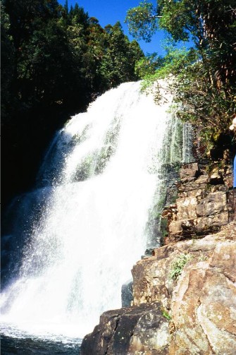
Fergusson Falls on the Mersey River
At 1.00pm we arrived at a narrow gorge, behind which was Hartnett Falls. The falls were quite high and very narrow, but I had seen pictures when the falls were in full flow. Today they were less than spectacular, but still very photogenic. Our guides set up a lunch spot on a small stoney beach after which we followed a narrow track to the top of the falls and a couple of large waterholes on the river. Barry again jumped in for a swim, creating a new Tasmanian Expeditions record - he is the first walker to swim or take a dip in every significant waterhole on the Overland Track. We wondered if he would be taking a dive into Lake St Clair tomorrow. Barry's antics soon had the 'Hutties' (who had arrived at Hartnett Falls) doing the same, though due to the fact young Billy was here, the topless brigade went in further downstream, out of sight of prying eyes (so how did I know?)
We decided it was time to return to the Overland Track. A 15 minute ascent took us to the track intersection. We then had a 2km walk and 200 metre ascent to Ducane Gap. The ascent took us through more forest but most of the track was boardwalk. We arrived at Ducane Gap (1070 metres) at 4.05pm. Due to dense vegetation there were no decent views but we topped up our water supply from a small stream. We then descended quite steeply through rainforest to Windy Ridge Hut, though this wasn't our destination for the night. Our guides knew of a secret campsite in the forest just north of Windy Ridge and we were shown to individual campsites in the forest. Ian and Billy were invited to join us.
This campsite is well used by Tasmanian Expeditions, but I have never seen so many mosquitoes in one area. If Pelion Plains was Leech City, then this place was Mosquito Metropolis. We spent most of the evening swatting the little blighters. The campsites were quite good, but I was concerned about the leeches. However, during our stay I saw none. A small stream wound its way around the edge of the camping area and provided us with more water supply. Our guides had a well constructed eating area where we could sit comfortably on a number of fallen tree logs. Obviously a lot of effort had gone into making this campsite quite homely. Our dinner was pasta with cut salami, sun dried tomato and black olives followed by Nathan's brilliant cheesecake, prepared earlier at the campsite. These guides were culinary geniuses when it came to our meals and I was quite surprised how well fed we were during the entire trip. In fact, so well fed I actually put on 2 kilos in weight when I expected to lose some.
This was to be our last night on the Overland Track. Our guides had organised the 11.15 ferry at Narcissus, so if we wanted to catch this boat we had to be up and away early in the morning, so at 7.45pm I entered my tent for the last time in Tasmania. I fell asleep to the sounds of our guides throwing rocks and sticks at the possums who had decided it was time to raid the group's food supply.
DAY 8 (Saturday 19th March 2005)
I was up at 6.15am and out of the tent for a quick breakfast before packing up my gear. Our guides told us stories of the one hour battle with the possums last night before they pesky animals gave up and fled. The mosquitoes had also disappeared after dark and so far had not returned. Today was our last day on the Overland Track and we had to be away by 8.00am for the 3 hour walk to Narcissus if we wanted to catch the 11.15am Ferry across Lake St Clair to Cynthia Bay. It was another clear sunny day, can you believe this? 8 days walking the Overland Track in Tasmania and getting only half a day of rain - we felt really blessed.
We moved off at 7.45am, found the right track out of the forest and within 10 minutes of walking the Overland Track had reached Windy Ridge Hut. This is quite a scenic hut, though small in accommodation - there are a number of tent platforms outside. The site had great views (though tree interrupted) of The Acropolis and Mt Geryon. There are water tanks here, but they seldom have any water. Thankfully there is a running stream just down the track.
Once again I headed off ahead of the others, with instructions to wait at the Pine Valley intersection. I noticed the clouds were coming in as I made my descent through light forest from Windy Ridge. I had views of the Acropolis to my right and the Traveller Range to my left and crossed a large number of creeks during my walk. At 8.50 I arrived at a sizeable well built bridge over a creek. I stopped here and waited for Karen & Jenny to catch up as I wanted my photo taken with this very photogenic scene. I continued on, crossing many creeks on my journey. At 9.55am I arrived at Pine Valley intersection a waited for the others to catch up - I didn't have long to wait. We were doing good time and felt we would reach the ferry with plenty of time to spare. However, as a precaution, Nathan sent James on ahead to make sure the ferry waited for us.
Looking across the Bowling Green towards the Acropolis
We continued on, I soon passed the bowling green, and area so flat and the grass so short it resembled a bowling green. The Acropolis towering above it made for a great photo. I now followed the track along well built boardwalks, having views of Mount Olympus until I reached the Narcissus River. Here a suspension bridge crossed and I waited for the others to arrive so we could take photographs of each other crossing the bridge. Then it was a short walk following the banks of the Narcissus River until we reached Narcissus Hut at 11.10am. A short 5 minute stroll took us to the jetty and we clambered aboard the ferry for the 20 minute ride across Lake St Clair to Cynthia Bay and the end of our trip. Andrew was waiting for us there along with our lunch which we enjoyed at the park headquarters while Currawongs loitered above us in the trees, hoping for a morsel of food. At 1.30pm we boarded the mini bus for the long drive back to Launceston.

Jenny cautiously crosses the suspension bridge over the Narcissus River close to the end of our journey
EPILOGUE
The Overland Track was a walk I had longed to do for over 10 years. After a number of attempts trying to get to do the walk and having some big disappointments I was finally able to do this 'Trip Of A Lifetime' and I did not come away disappointed. My only regret was the head cold that dogged me throughout the trip and thwarted my attempts to climb Mount Ossa. The company was excellent, the guides Nathan and James were brilliant and my fellow walkers Karen, Jenny, Barry and Bill were wonderful to walk with. However, next time I will seriously consider doing the trip on my own or with friends. I felt privileged to have walked the track in almost perfect weather and to have climbed Cradle Mountain on a clear sunny day, despite the difficult climb. I'll always remember the excellent mountain views, the lakes and tarns, the huts and tent platforms and walking the track itself. I'll certainly not forget the people I walked with and will not easily forget young William, Ian & Billy and of course, those topless bathing Hutties. Those who have walked the Overland Track before me will know how I feel about this walk, those who haven't yet done it do not know what they're missing out on. Yes, I intend to return to the Overland Track. It's only a matter of when.
Paul Ellis March 2005
CLICK HERE FOR
MORE PHOTOGRAPHS
BACK TO WOMBATS HOME