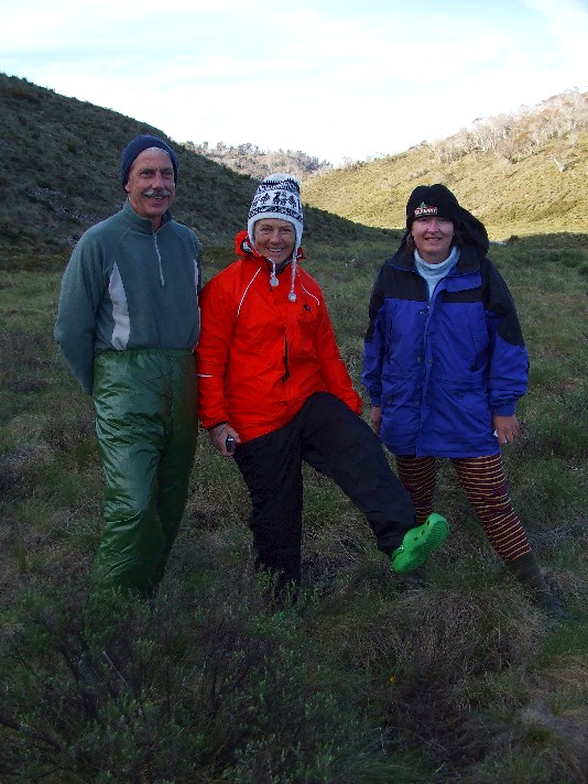
In early December 2008 I found myself joining up with 4 other Shoalhaven Bushwalkers led by Kynie Evison for 5 days planned hiking in the northern end of Kosciuszko National Park. Our drive from the Shoalhaven took us to the Australian Alpine region and the Clover Creek Roadside Camping Area on the Tooma Road not far from the village of Khancoban. Our itinerary had been changed several times during the previous 2 months - the first 4 days of this trip being a circuit walk that would take in the Snakey Plains and Tooma River before we ascend to the summit of Mt Jagungal, then head out at the Round Mountain car park. Joining us for the trip was Julie Davison and John & Gillian Souter.
I awoke early on Monday morning 1st December to rain on my tent and upon exiting found a completely overcast sky. During the next two hours as we attempted to pack up we found ourselves sheltering from sudden downpours under the hatches of the two four wheel drive vehicles. It was obvious the tents weren't going have a chance to dry, so I packed mine wet and attached it to the outside of my rucksack. We set off for the walk at 8.50am, driving the 4km to the Snakey Plains Trackhead where Gill, Julie and I were dropped off with the rucksacks while Kynie and John organised the car shuffle at our intended finishing point. Whilst waiting for their return we endured a brief hailstorm and another wet downpour.
Kynie and John arrived back at 9.40 and 15 minutes later we headed off down the Snakey Plains Trail in the light rain. We made our way through a forest of eucalypts, then the trail began an exhausting 200 metre climb up the ridge, despite the cool wet conditions we soon warmed up in our Gore-tex parkas. At 11.20am we arrived at the summit of this ridge and located a trig station (SMA1009) which stands at 1540 metres above sea level and is the first wooden trig station I've ever seen. Occasionally the mist would clear in the wind to reveal tantalising views of the valley, Dargal Mountain and the Tooma Reservoir to the north, but not long enough to take any decent photographs.
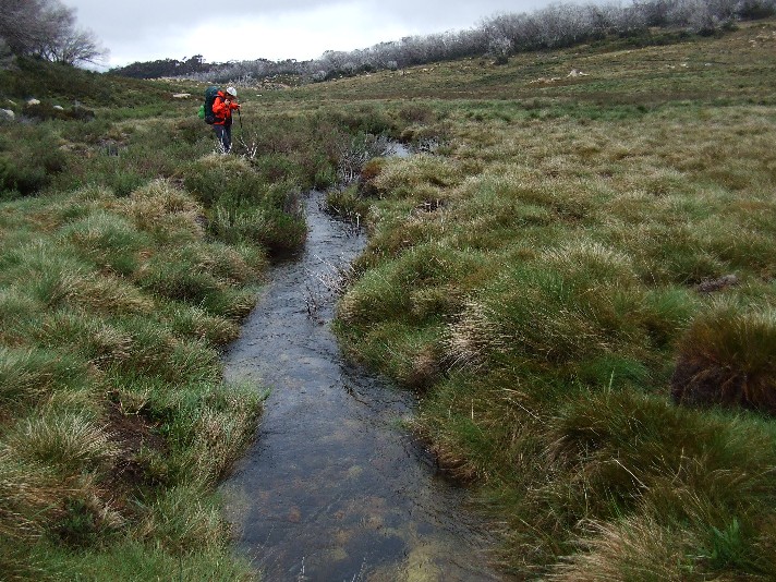
Kynie contemplates a possible dry crossing of the creek at Snakey Plains
We now descended to the Snakey Plains in light rain. An open buttongrass plain surrounded by low wooded hills opened up before us and we had to cross a narrow but deep creek which snaked (appropriately) its way across the plains. The water was so crystal clear we could easily pick out the details of the creek bed under the water. Crossing was not a problem, especially as every member of the group was using two trekking poles - a club first. The poles were to become invaluable to us as the four days unfolded. Narrow and wide water crossings were made with ease and the poles provided much stability on slippery rocks, fast moving water or for testing the stability of grass tufts on the creek banks.
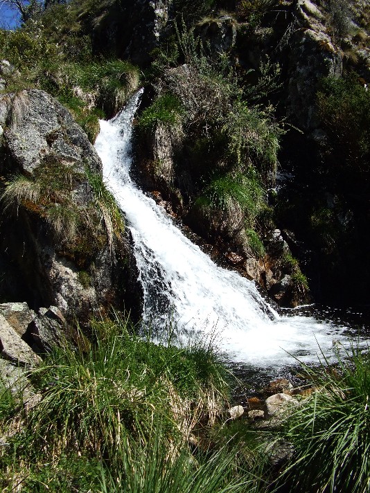
We now followed the Snakey Plains trail as it 'snaked' its way towards Wheelers Hut. At a section of low hill that was dominated by granite boulders we noticed Snakey Plains Creek tumbled through in a series of impressive cascades. All the waterways we were to see on this four day hike were fast flowing and running quite high. A big difference to the dead, grotty weed choked creeks back in our local Shoalhaven area. It was obvious the spring thaw was in full swing, even though there was no sign of any melting snow. We had been informed that the previous weekend, this area had received a late season dumping of two feet of snow during a storm, but all this had now disappeared. Despite this we saw none of the creatures that give this area its name.
We continued following a well defined trail as it descended through more forest before coming out on the side of some low grassy hills and as it was getting close to lunchtime we spread out as we attempted to reach Wheelers Hut. We must have walked a full kilometre when I heard a call from way behind, calling for John & Julie (who were a good 200 metres ahead of me) to halt we realised that Kynie and Gill were nowhere to be seen. We had no choice but to back track and soon came across both girls studying a map and GPS. We had somehow missed the turnoff to Wheelers Hut. Only a quick GPS reading had revealed our mistake. Heads down to keep the wind driven rain out of our eyes we had missed the faint track intersection. To make matters worse, we now endured another brief hailstorm, the stones the size of peas. We turned around and walked back along the track, finding the track intersection to Wheelers Hut. No wonder we had missed it, the track was quite grassy and veered off at such an angle that if you blinked, you could easily miss it, and we all did.
We followed the track as it descended to a narrow creek (most likely the Snakey Plains creek we had followed earlier), then ascended a short hill where the rustic Wheelers Hut stood at the edge of the tree line. We arrived for a late lunch at 1.40pm. This wooden slab hut was very homely and a welcome shelter from the light rain and cold winds. It was originally planned to be our overnight stop on the original walk plans until we discovered we could reach it by lunchtime on the first day and could complete the two major walking areas almost as a circuit. The hut had a dry sheltered living area and a bedroom that consisted of bunkhouse accommodation that would easily fit 6 walkers in comfort. A huge stone fireplace dominated the living area and the back of the hut provided ample firewood and the usual pit toilet. We sat on the front porch of the hut and enjoyed the views across the valley as we ate our lunch. Mt Jagungal loomed on the distant horizon.
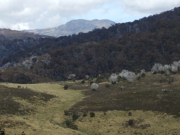
The view across the plains from Wheelers Hut to the impressive Mt Jagungal towering in the distance. In two days time we would stand atop Jagungal's summit
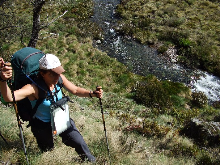
Amazingly as we sat eating our lunch on the front porch of Wheelers Hut the weather cleared. To save time this afternoon Kynie suggested that instead of following the boring fire trail that would take us several kilometres in a huge arc to our next destination, the Tooma River, that we cut across country by taking a couple of compass bearings. It would cut out some extra time and probably be more interesting with its three creek crossings. After a one hour lunch break we set off under surprisingly clearing sunny skies on a 95 degree compass bearing, descending a steep buttongrass covered plain and crossing two narrow creeks before taking an 83 degree bearing that took us up and over a steep ridge before it descended to an impressive winding Broadway Creek.
This creek was quite wide and certainly running fast. We followed it upstream, hoping to find a suitable and safe crossing point and this took us almost 500 metres out of our way. In the end we had no choice but to attempt a wet crossing. Using my poles I went first, without worrying about removing footwear. The water was freezing, the current was very strong and it required some strength with my poles to keep my balance and although the water came up to knee level, I made it across safely. I made my way to a previous bend where the others were removing their boots, socks and trousers for their crossing.
Kynie high on the slope above Broadway Creek after our crossing
We now had to back track to our original intended crossing point, but this was harder than expected as the creek passed an almost vertical embankment. We had to scramble up the hillside to get around it, again the trekking poles providing help with grip on the slippery hillside and once high up we decided to stay up, cutting through the forest and up the ridge to come out onto another grassy plain. 100 metres later we stepped out onto our fire trail and had cut out about one our of boring trail walking. We now followed the trail until we reached the intersection of the Hell Hole Trail and followed this as it descended a grassy hillside. A quick check of the map revealed this trail also went unnecessarily out of the way and Kynie revealed that if we cut across country we would meet up with the trail and cut out another 2km of boring track.
The grassy plains were very easy to negotiate and we got a great view of the Tooma River and we closed in on it, meeting up with the track as it commenced its parallel journey along the bank of the river as we followed it upstream. At once stage on a short bend we came across a large dark coloured snake with a yellow belly. We estimated it was over 2 feet long and could possibly be a Tiger Snake or a Copperhead. Julie was not impressed, especially after all the cross country walking we had been doing and as soon as we get back on track we almost step on a large aggressive snake. Worse was to come as we approached the ford in the river.
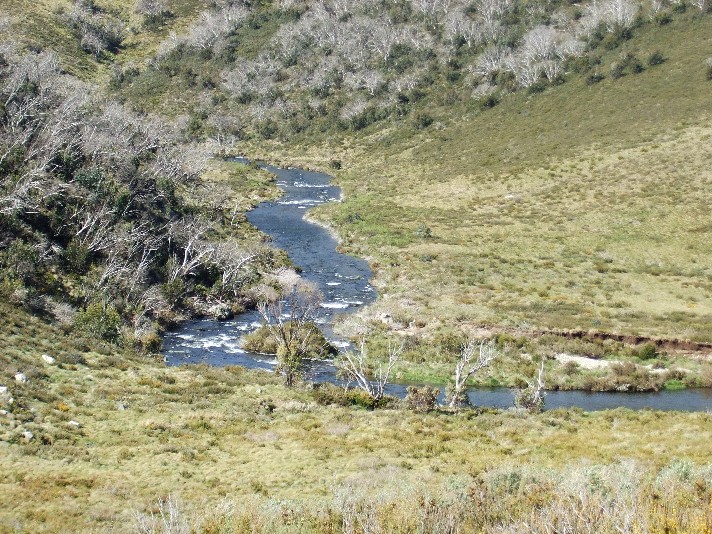
The Tooma River in full flow after a late spring thaw
Our track continued on the other side of the ford, heading into the hills beyond, but crossing the ford was going to be a problem. The rising river water had made this ford very deep (we could not see the riverbed) and the river was running extremely fast. There was no way we could risk a crossing. We had no choice but to head across country again and follow the river upstream and hope we could find a safe crossing. We made our way across the buttongrass plain, keeping an eye on the river, but no crossing looked possible and in places the river looked deeper and ran faster, it would be suicidal to cross. Worst still, after our recent encounter, we were now on the lookout for snakes. We crossed a swampy section where another creek cut across the plain to join the Tooma, but no crossing could be found. To make matters worse a stiff wind had come up.
We decided we had no choice, as it was now 5.30pm, but to pitch our tents here on the buttongrass plain beside the Tooma River and try for a crossing next morning. We had two choices, follow the river further upstream in the hope of finding a safe and suitable crossing (John had noticed on the map there are many creeks feeding the river so if we can get beyond these we may be able to find suitable crossing conditions, and he had located a possible cross country route to meet up with the track) the other option was unthinkable, returning to the start via the Snakey Plains and driving to Round Mountain to finish the walk from there. It was a depressing feeling as we prepared our dinners and retired to sleep in our tents on very uneven ground.
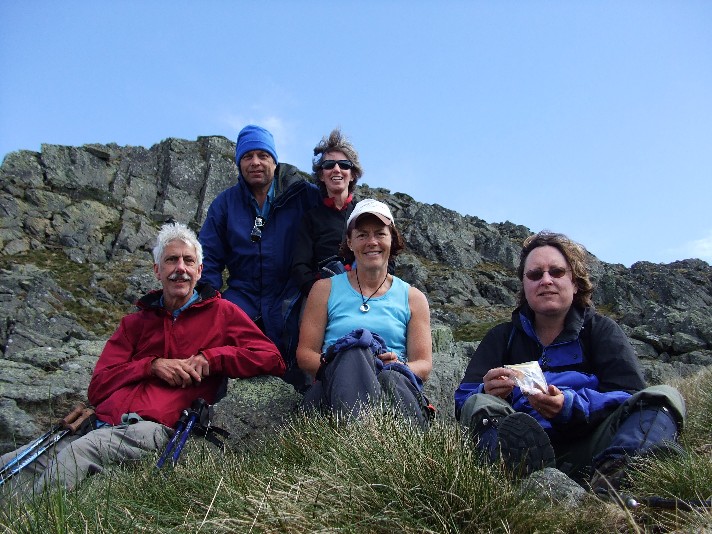
Tooma River campsite fashion parade (Where are the fashion police when
you need them?)
L-R John Souter, Kynie Evison and Julie Davison
I was awake just before 6.00am on Tuesday 2nd December and exited my tent to find it covered in frost. My boots and damp socks were also frozen but I bravely put them on knowing they were likely to get soaked with yet another wet crossing this morning. I was the first of our group to get up and it wasn't until 7.30 when the final member of our party appeared from her tent. The rising sun had melted the frost and all tents were soaked, but the strong winds soon helped dry them. It was a clear sunny day with the few clouds being driven along by the strong winds. We were all packed by 8.50am as we moved off up river, attempting to locate a suitable crossing point.
As each bend in the Tooma River was reached we were faced with still fast running deep water, it felt like we could spend hours walking alongside the river bank. As we checked the map at one stage we noticed a strange animal watching us from the other side of the river, it turned out to be a black and white wild dog which quickly retreated up the nearest steep hill when Julie called out to it. We must have walked a good 2.5 kilometres from camp when we reached what appeared to be a shallow section that wasn't flowing too fast. John wasted little time testing the water and made it safely across the other side. I went next, refusing again to remove my footwear, and Julie followed suit. Kynie and Gill took the trouble to change out of their dry gear first. The water still had a very strong current to it and the trekking poles proved invaluable for stability, especially on the very slippery river bed rocks.
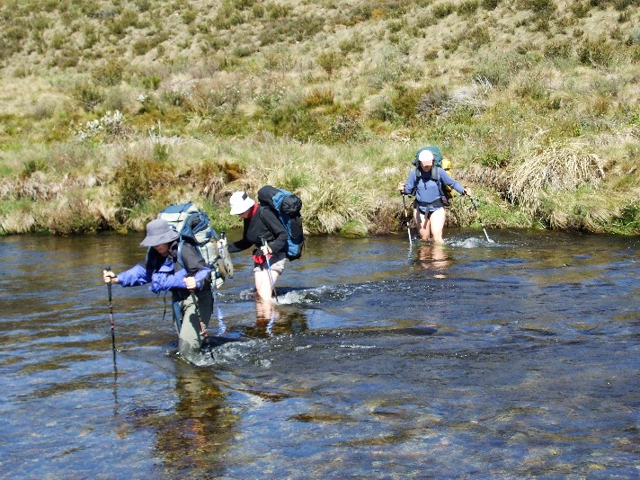
Crossing the Tooma River - Julie, Gillian and Kynie
Everyone made it across safely and we now crossed an extensive buttongrass plain come swamp to the base of a wooded ridge where we stopped for morning tea and a chance to either dry out or put footwear back on. After the break we followed the bottom of the ridge, a small animal track, which we found had been created by a number of wombats judging by the large burrows in the hillside. We ascended a grassy ridge and descended the other side where we discovered a fast flowing creek running to our right. A quick check of the map revealed we need to keep the creek to our left, so we changed direction and soon found ourselves climbing through a thickly forested ridge. Kynie had again set a compass bearing of 57 degrees in hope of locating the Hell Hole Fire Trail further along. We had a long way to go yet.
The ridge was tiring, constantly battling our way through thick foliage as we climbed higher. It was with great relief when the top of the ridge appeared and our cross country walking levelled out and we soon found ourselves crossing an open grassy plain. Keeping to the compass bearing we crossed three minor creeks before ascending yet again through a forested ridge to surprisingly exit onto our fire trail. It was just after midday and for all our efforts this morning, a check of our map revealed we had only come about three kilometres from the ford we had tried to cross yesterday. We found a small embankment just off the track where we decided to stop for lunch. It was a bad decision, for no sooner had we removed our rucksacks and sat down to eat than we were swarmed upon by hordes of tiny black ants. Most of lunch was spent brushing the annoying insects from our food, clothing and packs.
A short ascent straight after lunch on the trail revealed a bend in the road and a close view of Mt Jagungal in front of us. I wondered where the name Jagungal came from and what it meant, as the mountain resembled more the shape of a toadfish with its curved ridges, not a very romantic thought I know. We continued following the trail for a couple more kilometres until we reached another intersection, this one the Round Mountain Fire Trail. We turned right and followed this as it descended the grassy valley opening up in front of us. John, Gill and Julie seemed to be in a big hurry as they left Kynie and myself behind as we took in the delights of the surrounding countryside and the views of the ridge tops. The forest throughout this area has a feathery appearance and sadly this has been caused by the huge numbers of dead trees from the 2003 bushfires, though new saplings are appearing throughout the forests here.
We caught up to the others as they stopped to view some scattered boulders dominating one hillside, resembling a topsy turvy druid circle of shaped stones. As we moved on we crossed a deep creek, but this time via two large concrete slabs which made us wonder why something like this could not be utilised at the deep ford we encountered on the Tooma River yesterday. Perhaps that section is used less often than the Round Mountain trail to Mt Jagungal. At 2.05pm we arrived at a small track junction signposted to Durschkos Hut and 5 minutes later we arrived at this small but impressive weatherboard building.
The hut had a narrow eating area, complete with benches for sitting on and some shelving for cooking, but dominating this area was a large pot bellied stove. The two sleeping areas had one bench, so it was obvious the majority of hikers slept on the floor. Outside the hut was a small grassy mound with the remains of a log fireplace. We utilised the logs to sun dry our socks and boots, especially myself and Julie. Across a small swampy section was a set of rocky boulders that formed an impressive throne, which John used to shelter from the wind to do some reading. Below the cabin was a small fast flowing creek which supplied us with fresh drinking water and below that, a wider section for those who wished to brave the cold elements to have a wash. On the hill behind the hut stood a pit toilet and behind that, in the woods was an impressive overflow camping area. Had it not been so windy today Iím sure we would have chosen this campsite for the night as our forays for firewood revealed not only a magnificent view across a valley, but also a short cut to avoid another long section of walking track.
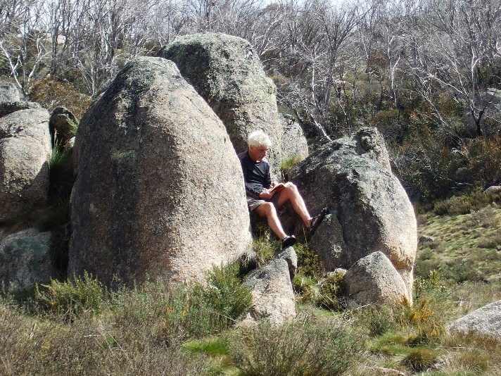
John finds a comfortable spot out of the wind to while away the afternoon reading near Durschkos Hut
As we had arrived rather early in the afternoon there were thoughts we could do the side trip to Mt Jagungal today as it was guessed that we were no more than 4 hours return to the top of the mountain. It was decided against as we were all very tired and we would be heading that way tomorrow. Instead we spent the afternoon gathering firewood, relaxing in the sun, reading or catching a quick siesta in the cabin. I chose the latter, not wishing to put up with the freezing cold gusty winds that hit everytime you stepped outside. The entrance to the hut was also blessed with a swallows nest, but the poor bird was scared away by our presence. An interesting sideline to our stay at the hut was a read of the hut's logbook, one entry revealing that the hut could well be haunted.
By 5.00pm most of us had cooked and eaten our dinners and we had the pot belly stove going, and it worked too well, by 8.30pm everyone had decided to call it a night. Strangely I was the only person who utilised the sleeping bench, everyone else content to sleep on the floor and it was so hot from the stove that for the first and only night of the trip I slept shirtless with my sleeping bag zipped open. Suffice to say there were no ghosts to bother us during the night, but I wished I'd also organised myself to sleep on the floor as my sleeping mat continually slipped on the shiny painted bench surface during the night.
I was first up again next morning Wednesday 3rd December at the ungodly time of 5.50am. We have a clear blue sky, though there are a few clouds around and todayís forecast was for strong winds - they werenít wrong. Today was going to be huge, with the side trip to Mt Jagungal followed by a long walk towards Round Mountain Hut in the afternoon. We set off from Durschkos Hut at 8.00am and cut through the camping area we had seen yesterday and rejoined the Round Mountain Fire Trail on a flat open plain. Mt Jagungal towered on the horizon and we soon commenced a short ascent through an avenue of dead snow gums to link up with the headwaters of the Tumut River. Here it was no more than a small delta of tiny cascading streams running off the side of Jagungal. We crossed the main stream and located a nice hidden spot to leave our rucksacks. There was no way any of us were carrying our packs up this mountain. To protect us against the wind chill we all put on our rain parkas, carried a litre of drinking water and something small to eat.
By 9.00am we were ascending the main ridge to Mt Jagungal, and what a steep climb this was. I'm glad we decided to leave the heavy packs behind. A narrow faint track took us steeply to the ridge top 1900 metres above sea level, through patches of wildflowers and snow gums. The more I stopped to take photographs the further I fell behind the others. It didn't concern me, I was more intent on enjoying the scenery and pacing myself today. The final climb onto the ridge top required a short scramble across some rocky ground and on top of the ridge was the rest of the group. I also found I had mobile phone reception for the first time during the trip and Jagungal was the only place we could send messages to friends and home.
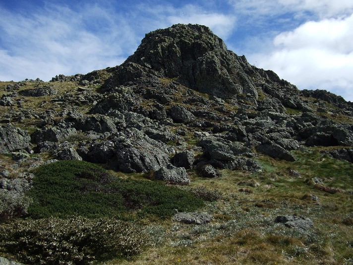
The summit of Mt Jagungal beckons from the top of the ridge
We now had a flatter walk as the ridge line made its way through more snow gums and wildflowers and the track was reasonably well defined. In the distance 30 kilometres away the snow topped main range stood out, with Australiaís highest mountain Mt Kosciuszko. The main bulk of Jagungal towered above us and after passing what remained of an old fence line the track started to ascend again as we left the tree line behind us and skirted around the back of the mountain, always ascending. I was amazed when Kynie revealed that even past 2000 metres above sea level, you can suffer from mild altitude sickness. Everyone seemed to be breathing heavier now and we were all thankful to have brought along the trekking poles. The track was becoming less defined, but still easy enough to follow and at a number of spots a stone cairn showed the way. The beanie was put on as the icy wind attempted to freeze the ears and I caught up to the others as they took a much needed rest break in the lee below the summit. This gave us a chance to utilise the timer on several cameras to take group shots.
Group shot just below the summit of Mt Jagungal (Aren't you cold Kynie?)
The final ascent was no problem. We made our way to the final cliff line and located a small rocky pass through which we could climb. The brick obelisk on top revealed the mountainís highest point and the location of Jagungal Trig, though the metal frame and vane have long since fallen to the bottom of the cliff as we noticed them prior to the final ascent. At 10.30am we emerged on top of Mt Jagungal and were almost blown over the edge by the strong winds. We bravely took it in turns having our photographs taken at the trig before hunkering down between 2 large rocks at the top of the pass to shelter from the strong winds.
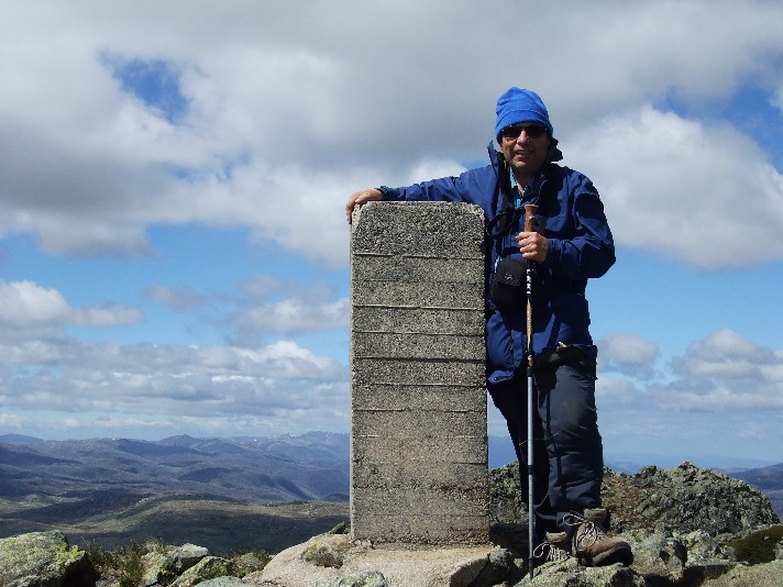
Hanging on for dear life at the top of Mt Jagungal as the strong winds attempt to throw me over the edge
When we did brave the winds we were able to take in 360 degree views from this high point 2062 metres above sea level. Round Mountain stood out to the north and there were still patches of snow further along Jagungalís flanks where the warmth of the sun often doesn't reach. We ate our morning snacks whilst sending text messages on the phone. We were unable to call anyone as unexplainably the signal strength fluctuated from 4 bars to none very quickly. We decided it was too cold and windy to remain up here, despite the magnificent views, so we descended the short pass back to the grassland and quietly made our way back down the mountain, soon reaching the tree line. The descent was certainly much easier, though it was hard on the knees and by 11.40am we were back at our rucksacks deciding on an early lunch.
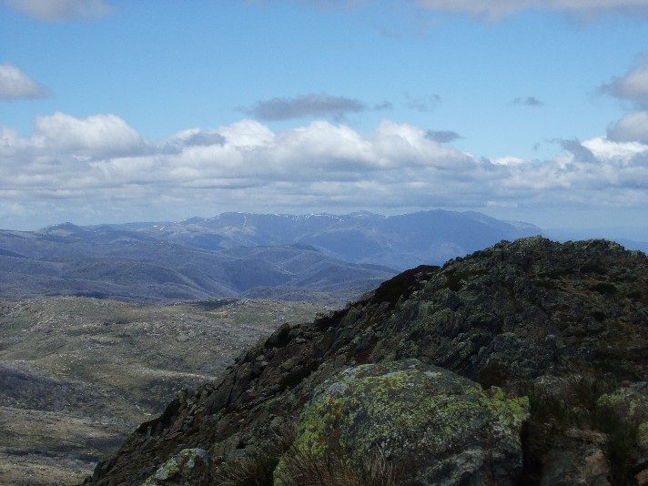
Looking towards the Kosciuszko Main Range in the distance from the top of Mt Jagungal
While we were enjoying lunch we were amazed to see a group of 30 hikers turn up at the tiny campsite on the creek below our position. Yes, we counted them and joked it was the Shoalhaven Bushwalkers on track group on a day walk (well, it was a Wednesday after all - and there were enough of them) it in fact turned out to be a school group from Galston High in Sydney going for their Duke Of Edinburgh Gold Medals. We chatted to them as they passed us on their way to the summit.
At 1.15pm we moved off heading out along the Alpine Walking Track as it made its way north east below Mt Jagungal. This part of the Alpine Walking Track is also called the Grey Mare Trail and it ascends gradually to pass a weather station below Jagungal's northern flank. There were several narrow creeks to cross on the trail and at this time of year the track can be quite muddy and slippery. Once again it was great to have the trekking poles for that added traction and stability. The 2003 bushfires had been quite intense here and we found it quite depressing to walk past huge numbers of dead trees. We continued to ascend to O'Keefe's Hut, now in the process of being rebuilt by NPWS after it had been destroyed by fire. I took the opportunity of a rest break here to tend to my feet. I noticed during this afternoon's walk I was developing a few hot spots and was distressed to locate a small blister on one of my toes. I could only tape it up and hope for the best. There was still another 4 hours or more of walking to go and it was now 2.00pm.
We continued following the Grey Mare Fire Trail north east as it descended steeply to Bogong Creek. We all removed footwear and socks for the icy cold crossing as it was just too wide to attempt a rock hop across, even with trekking poles. We now had a steep ascent up the other side, but soon arrived at a faint intersection where we turned left and headed north along what is known as the Farm Ridge Trail. This trail is certainly much nicer to walk and is an old cattle drovers route. It's narrow track winds its way through snow gums and eucalypts. The forest was quite sparse, obviously due to past cattle grazing and the grass is lush and long. Occasionally we caught glimpses of Round Mountain in the distance. It made for mostly enjoyable easy walking and we put the kilometres behind us, taking it in turns to lead from the front. We continued onwards, my heavy pack now causing some strain in my neck and upper back, the straps chafing my shoulders. My knees were starting to feel the strain and I could feel blisters developing on my feet in several spots, despite my attempts to patch the hot spots with tape. For the first time on the trip I was starting to feel just a little miserable.
Eventually we began our descent towards the Tumut River. This was quite spectacular as the river cut its way through a flat plain with the steep ridges of forested hills on both sides. The descent got steeper and we eventually reached a small creek where we drank thirstily and topped up our water. Already today I had managed to drink over 4 litres from my hydration bag. The track now crossed a swampy plain to the bank of the Tumut River which was flowing quite deep and swiftly, though not as bad as the Tooma River had been earlier on the trip. Once again it was off with the boots, socks and in some cases, the bushwalking trousers as we made our way across gingerly. Once again, if the rocks on the river bed weren't painfully sharp, they were very slippery and it was with a sigh of relief that I stepped on the opposite bank.
We all agreed we had certainly had enough walking for the day, Round Mountain Hut was still over 2km and a 180 metre ascent away. It was now 5.45pm and next to the river was a nice flat well grassed camping area, complete with fireplace, though the nearest trees were high up on the ridge above us. I gave my sore feet some respite by slipping into my pair of soft cabin slippers. We set up our tents, Julies more resembling a kite as strong winds threatened to carry it away down the valley or into the fast flowing Tumut. A quick exploratory of the area revealed several large Wombat holes, a fast flowing creek upstream from the campsite and a really wonderful tent side vista. Dinner was quickly cooked and eaten and with the wind still blowing hard we all decided on an early night at 7.30pm. No one considered lighting the campfire this evening. I must have fallen asleep immediately.
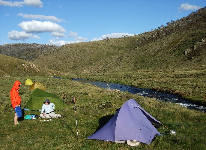
Our campsite on the level bank next to the Tumut River
Thursday morning 4th December, I was awake at 6.00am and amazed to find my entire tent frozen solid. Exiting the tent I found the surrounding grasslands a dazzling white. Obviously with the wind dropping overnight, a cloudless starry night sky and the fact this valley is almost treeless, left us exposed to the perfect frosty elements. The Tumut River was obviously boiling judging by the mists rising from it. I patiently waited for the sun to come over the north eastern ridge and commence melting the ice on the tents and grass tussocks which became rather wet. We had a cloudless blue sky which meant that if the winds stayed away we would swelter. By 9.00am my tent was totally dry and I proceeded to pack my rucksack. It was 10.00am by the time we headed out, but not via the steep track heading up the ridge. Kynie had better plans, we would be following the course of the fast flowing creek just up river from our campsite. A check of the topographic map revealed the main track crossed it further up the ridge and the cascades looked very photogenic.
We certainly got a number of very good cascade photographs as we set out along the creek bank, but as the creek ascended, so did the banks on either side and we found ourselves scaling steep inclines of grass tussocks to sometimes 50 metres high above the creek and rocks below. It made for some nervous negotiations as one slip would definitely lead to disaster. Again the trekking poles came into their own, allowing us plenty of purchase on the steep slopes. They certainly turned out to be possibly the most important item of equipment on the entire trip (except maybe for a warm sleeping bag) John found an easier way, he just rock hopped his way up the creek.
Cascading Creek which eventually dflows into the Tumut River. We followed this creek some distance
A little further on we found ourselves back at creek level and crossed over, but we were immediately forced to take another detour as a grass tussock revealed a tiger snake basking in the morning sun. We weren't sure how big he was, half the snake was hidden under the tussock. The snake refused to move, despite our presence and none of us were willing to prod it, even with a trekking pole. In the end we found the easiest way was to give the snake a wide berth. We headed up the steep slope, carefully eyeing all the grass tussocks for more slithery surprises, but we got the surprise when we reached the top of the slope to find the main track in front of us.
We now had a one kilometre ascent to Round Mountain Hut and we all set off at our own pace, knowing we would have morning tea there. It really wasn't too long before we arrived and thanks to the treeless open camping area we'd stayed at last night, several of our group utilised the hut's pit toilet which provided the best dunny view in the area we'd so far walked. With the door open it framed the entire vista of Mt Jagungal, far in the distance - we certainly did walk a long way yesterday. Round Mountain Hut itself is an unimpressive looking corrugated iron shack, but inside it is very cosy and well stocked with necessities for the overnight user, including 6 bunks, certainly very impressive on the inside.
35 minutes later we were heading up the track to the finish, just 2km away. As we reached the intersection with the Round Mountain Trail low and behold, there's some of the Galston High group we had met yesterday. They must have really power walked this morning as they had spent last night in and around Durschkos Hut. By 12.05pm we had arrived at the car park and the end of this four day walk. Amazingly the beers in Kynie's car esky were still cold, so we celebrated the finish with an ice cool James Boags, much to the envy of several nearby school teachers.
It certainly wasn't the end of our week though. We drove into Khancoban where we enjoyed lunch and made phone calls to loved ones. After farewelling John & Gill (who had decided to head home early) Kynie, Julie and myself headed for the local caravan park where we paid to use the amenities. The shower was good I can tell you. From there we doubled back to the Tooma Road where we took a side trail to the abandoned town of Ravine (Aptly named) as the road is narrow, rough and steep with no guard rails and plenty of sheer drops to the valley below. Definitely a 'White Knuckle Ride'. A huge sigh of relief when we reached the bottom. Ravine was once a thriving copper mining community, but all that's left now are filled in mine shafts, foundations of buildings and a few dirt roads. We set up camp by a narrow creek.
Next morning we were greeted by rain. In the hope it would go away we took a short 45 minute bushwalk, following one of the old overgrown trails into the forest until we could go no further. The rain got heavier as we returned to the campsite and we were faced with packing up 3 very wet tents. Furthermore, Kynie's intentions were to cross the ford on the Yarrangobilly River and follow the Lobs Hole Trail all the way to Talbingo. Unfortunately, like in the recent walk, the water levels were too high which meant we had to drive the 15km road we had driven in on yesterday and go to Talbingo the long way.
I must admit going uphill, the drive was easier on the nerves and highlighted by the sighting of a young dingo walking along the road in front of us. We also encountered a thick fog that got worse as we got higher. Our attempts to go take a look at the ski fields at Mt Selwyn revealed nothing but White (Fog) so we drove over to Three Mile Dam camping area where we decided on lunch in the mist. The camping area looks magnificent, with its grassy campsites, iron covered fireplaces and wooden picnic tables. The waters of the dam were probably very scenic too, if we could have seen them through the fog. Laughingly the fog started to lift as we got back in the car for the drive up the Snowy Mountains Highway to Talbingo.
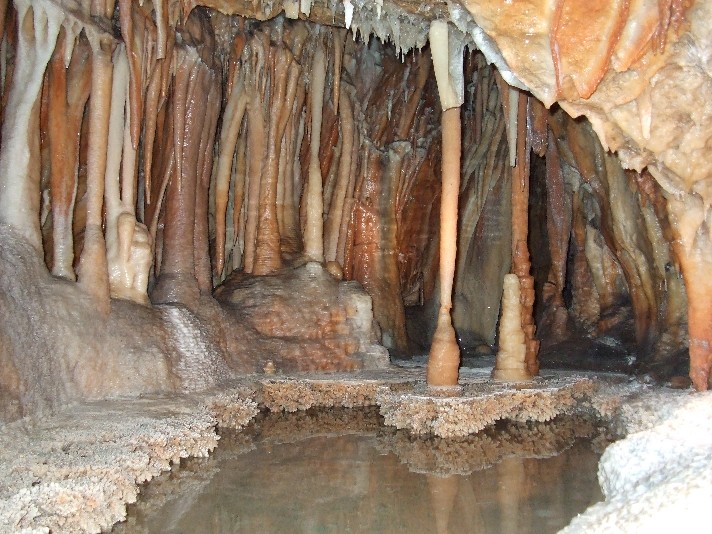
Inside the Jillabenan Cave at Yarrangobilly
Our next stopover was at the Yarrangobilly Caves area where we paid a visit to the thermal pool and took a guided tour of one of the limestone caves - Jillabenan Cave. Our day not over, we linked up with the Lobs Hole Road where we should have originally exited from Ravine and drove in several kilometres to walk the trails around several ruined homesteads which included the very impressive Jounama Homestead. After all this we lobbed into Talbingo at 7.10pm and were lucky enough to get a 4 berth cabin for the night. Next morning we drove home via Tumut, and the Hume Motorway to the southern highlands and back to Nowra. Certainly a trip with a difference.
RETURN TO WOMBATS HOME