2 SEPARATE WALKS (by Paul Ellis)
Maps - 1:25,000 Tianjara & 1:25,000 Endrick
Photographs feature images from both walks and were taken by Max Wharton & Paul Ellis
On Sunday 22nd August Max Wharton and I set off for the Sassafras entrance to the Budawangs for our hike to Folly Point. A sunny clear day greeted us as we drove out of Sanctuary Point and headed for the Braidwood Road. This dirt/gravel road has always been a nightmare drive, but today it was as smooth as bitumen (obviously recently been graded) and we breezed along at a reasonable speed, reaching Sassafras in just 30 minutes. Max was then given the task of getting out of the car to open and close each of the 5 gates along the access road. His actions revealed it was rather chilly outside the car at this altitude and I was quite happy to be the driver. We finally arrived at the NPWS car park at 8.15am and within 5 minutes had put on our rucksacks and set off south down the road.
I had previously undertaken this walk 7 years ago in August 1997 with Gary Williams. Back then I had found this walk most enjoyable. The views had been excellent, the campsites were adequate and the walking track well defined and easy to negotiate. However, the NPWS (National Parks And Wildlife Service) decision in late 1996 to move the car park from Newhaven Gap to a position a good 8km closer to the Braidwood Road has meant that the amount of bushwalking traffic has decreased dramatically over the years. Most bushwalkers baulk at the thought of walking an extra 8km along a rather boring open dirt road with very little points of interest. It means that a good 2 hours have passed before you even reach the old Budawang entrance at Newhaven Gap. With the reduction of bushwalking activity in this area many tracks have almost disappeared with little use. It was this thought that bothered me in the weeks leading up to the walk.
Max and I set off down this rough dirt road, quickly passing the impressive camping area on our left 600 metres down the road from the car park. This site includes a large water tank and a covered shelter complete with two large bench tables. Max jokingly commented that this site would do nicely (I'm sure later on he'd wished he'd been more serious). The road ascended through open heathland with only brief glimpses of Mt Tianjara to the east and unimpressive hills to the south and west. We were quickly warming up and as we came round a small bend in the road we came across the sight of a Red Belly Black Snake sunning itself in the middle of the road. This despite the fact it was still August and the last month of winter. The snake was approximately 2 foot long, not the biggest I've come across, but big enough to cause a nasty painful bite. At our approach the snake slithered into the safety of the roadside heathland before Max could snap off a decent photograph.
Just after passing Bhundoo Hill (Map ref - Tianjara 505059), about one hour into the walk and still ascending we were startled by a call of "Good Morning" coming from somewhere nearby. Looking around and expecting to see a well hidden tent on the roadside we were surprised to see a lone cyclist bearing down on us from the rear. He pedalled along side us for a short distance, asking us where we were headed and telling us he was heading for Nerriga via Quiltys Mountain. He was quite impressed when we answered his question of how long we had been walking since the car park, telling us we were setting a good pace. He then bade us farewell and rode off into the distance.
By 9.45am we had reached a distinctive unnamed landmark at the side of the road which I've named the 'Mini Monolith' (Map Ref - Tianjara 498034), it's just a rock outcrop, but a good place to have a short rest. despite the fact it was quite windy here we found a sheltered spot and took a 10 minute rest break before continuing. We soon reached the main gate at Newhaven Gap and followed the road for 500 metres to the entrance to the Coast And Mountain Walkers Track, passing two small groups of walkers coming the other way from Quiltys (these were the only other bushwalkers we would see for the entire walk).
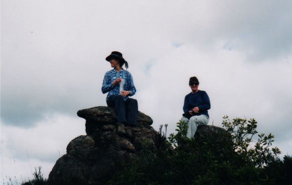
Karen Davis & Sandra Kelley take morning tea on top of the 'Mini Monolith' near Newhaven Gap
The start of the track is marked by a rock cairn and the faint words 'Folly Point' and an arrow scratched into the rock face (Map ref - Endrick 490023). We were exactly 2 hours from leaving the car. We headed into the bush, following a narrow track that occasionally opened up at rock platforms marked by small stone cairns and before long were ascending through a rock field that gave us great views of Mt Tianjara and Kangaroo Hill across the Clyde Gorge to the east. It was at this rock field that Gary and I had taken a long rest break 7 years before. However, the vegetation had grown so much in this area there was no chance of a repeat break. The dense vegetation here was a warning of what was to come.
The track levelled out and we found ourselves crossing a number of rock slabs marked with cairns, then we hit the scrub proper, and what a nightmare it proved to be. The scrub had closed in on the track, most of it prickly Hakea. It slowed us down considerably as we attempted to get through the tangle without becoming human pin cushions. At knee level the sword grass and other plants tugged at our feet, attempting to trip us over at every opportunity, it was taking longer than expected to reach our next rest point, just before the descent to a small grassy plain.
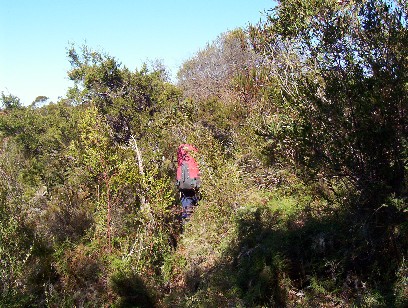
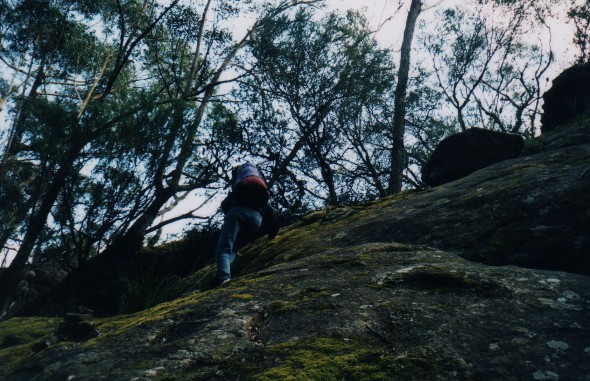
Paul almost vanishes into the thick scrub that crowds the trail to Folly Point
It was 12.15pm when we finally dropped the packs for a well earned rest on the cliff edge (Map ref - Endrick 493997). We had tree interrupted views here, to the east along the Mt Bushwalker escarpment, south to Mitchell Lookout and south west was the unmistakable mountains of The Castle and Shrouded Gods. Max and I discussed the amount of time it had taken us to reach this spot and I estimated we were a good one hour behind schedule. No big panic though, we would still reach camp with plenty of daylight.
With a short break over we descended to the 'Grassy' plain. The descent was quite easy and the track soon levelled out, but the grassy plain? My thoughts went back to 1997 and a photo Gary had taken of me crossing a plain of low grass. What faced us now was a track that wound through a forest of Banksias and Hakea - how times change. The plain crossing is a short one and we were soon ascending to a small rock platform that gave us great views of The Castle, Shrouded Gods Mountain, Mount Cole and Donjon Mountain in the distance. We then descended a short way, during which I took a heavy fall, landing painfully on my left hip and knee. At first I thought I'd done serious damage but this passed as I eventually got back to my feet. The pain was quite severe to start with but soon dissipated at I continued walking. We now ascended to Mitchell Lookout, a steepish climb but not too long and after a narrow squeeze between two rock slabs we were standing on Mitchell Lookout. (Map ref - Endrick 493988)
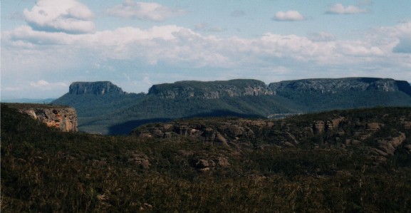
A great view looking across to The Castle, Shrouded Gods Mountain and Mount Cole from the rock platform below Mitchell Lookout
It was 1.20pm and we decided it was time for lunch. Mitchell Lookout mainly gives a few views east across the Clyde Gorge and north showing us where we had walked so far. One note of interest is the topographic map's marking of this point which is about one kilometre north of where it should be. We relaxed on the rocks letting the sun beat down on us. It was now becoming quite a hot day and the previous wind had died down. At 1.50pm we donned packs and set off for Folly Point.
We descended via another overgrown track, crossing rocky platforms again marked with cairns. On one occasion we missed the track turning and wandered about 50 metres down an animal pad before realising our mistake. The state of the tracks now making us aware we had to be very careful to watch for false entrances. Animal pads were everywhere, making the area something very similar to a maze, only a specifically placed cairn gave us the comfort of knowing we were on the right track. At 2.20pm we arrived at the Ravine.
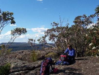
Paul takes lunch at Mitchell Lookout
The Ravine is a steep rock slab that drops about 50 metres to the gully below. A popular track notes book states a descent can be made using the aid of a fallen tree, but the tree has obviously slipped further into the ravine. I stood there thinking "How in the hell did Gary and I get down there in 1997?" Of course the descent looked harder than it was. Max too was voicing his concerns, but I remembered how we had handled the descent before and went first to show the way. After carefully negotiating the first slope we crossed a small ledge to a lone grassy plant where we could drop down to a second ledge and make our way to a spot below where we started, then on our backsides inch our way down the next slope to the fallen tree. After this itís a simple scramble next to the tree's fallen trunk to the gully below. Easier than it looked.
Now we had to climb again. The ascent was a debris field of stones, dead logs and branches and assorted leaf litter, but the way was marked by numerous stone cairns. Eventually a track started to appear as the ascent levelled out. I remembered that in 1997 this section was quite boggy and the most difficult of the whole walk as we had to negotiate a number of fallen logs. The logs were still there, but with our drought conditions over the past year the ground was quite dry, however, again the vegetation has decided to crowd the track and the going became quite difficult, in fact the walk through this section was taking a lot longer than I expected. I remembered a section of track that came out onto rock platform dotted with many Banksias and views of Pigeonhouse Mountain and The Castle. Of course, the vegetation has bloomed in the past 7 years. Every time I came to a spot that looked like it may open we were faced with yet more dense scrub. To add to this we could hear thunder in the distance and the occasional opening in the vegetation revealed some ominous dark clouds forming in the south-west. By the time we found ourselves on any sizeable rock platform we had easily bypassed the rock cairn marking the track to the camping area. Of course this was a blessing in disguise as the cairned route eventually led us to Folly Point Lookout (Map ref - Endrick 485964)
The views from this spot were equal to any I have seen anywhere else in the Budawangs and would probably better those seen from Mount Bushwalker. From one angle you felt like you could almost reach out and touch The Castle, Shrouded Gods and Mount Cole, in another direction you could look straight down the Clyde Gorge to Byangee Mountain with Pigeonhouse on the left. The storm we had seen earlier was now closing in. Dark black clouds came over The Castle threatening rain, so Max and I quickly retraced our steps to find the cairn marking the track to Folly Point camping area. The trouble was, some joker had arranged a separate set of cairns with sticks pointing which direction to walk. We suddenly found ourselves back at the lookout after walking a sizeable circle. We double backed again, fighting back that twinge of panic that we werenít going to find the right track and end up trying to get back to the car in the dark.
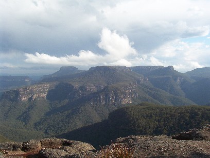
The view from Folly Point Lookout with the storm closing in
We eventually found the right cairn though, also marked with a large branch pointing to a narrow track through some thick vegetation. We crossed what to me was a familiar creek bed and we were soon crossing the rock platform following a large number of stone cairns spaced at approximately 10 metre intervals. Before long a familiar rock formation came into view and we descended the rocky slope to the tree hidden camping area below, arriving at 3.50pm.
We gratefully dropped our heavy packs and studied the camping area. Although familiar, it had changed considerably in 7 years. The spot Gary and I had pitched the tent looked decidedly smaller, the communal area next to the creek looked bigger. There was water in the creek but it was running at barely a trickle. There were less tent sites than I remember, but the area we collected our drinking water was still there and looked clear, though it was full of large tadpoles. We located the visitors book on a rock slab near the rock cisterns on the creek and I did the duties of signing us in - noting that there had been someone else passing through just one day earlier, but also noting that this site received no more than one walking party each month. Because it had taken us so long to get here, an exploratory of Watson's Pass which takes you off the escarpment and into Hollands Gorge was out of the question. Maybe next time.
Max and I returned to our rucksacks and busied ourselves with pitching our tents, just as it started to rain, though only lightly and only for about 10 minutes. Once the tents were up and sleeping gear organised we brought the cooking equipment and food to the communal area to prepare dinner. The first thing we noticed, on a stump next to the fireplace was a small penknife, obviously left there by the previous campers. This spot must be a magnet for walkers who lose their precious knives, for when I returned home and unpacked my gear, I found I too had left my beloved Swiss Army Knife at the campsite. Dinner started with the obligatory cup-a-soup, but Max was not feeling too well after the day's exertions and decided not to have any dinner, it wasn't long before he disappeared into the nearby scrub to bring up his cup-a-soup. I also decided against the freeze-dry for dinner, opting instead for the bacon and eggs I'd brought along for tomorrow morning's breakfast (I was keen to test out my new Trangia Teflon coated frypan which proved to be a marvellous addition).
By 6.30pm we had cleaned up and got a small fire going to keep us warm, we discussed the day's walk and realised it had taken us nearly 8 hours to reach this point. As I had to be home tomorrow in time to get to work by 5.00pm I guessed we would have to be packed up and ready to go by 8.00am, though I was quietly confident we could reduce the walking time to around 6-7 hours which would get us back to the car no later than 3.00pm, plenty of time to get home and get ready for work. The day's exertions called for an early night and just after 7.00pm Max and I retired to our respective tents to get some much needed sleep. I crashed almost immediately.
Day 2
I remember waking up several times during the night. Just before 5.00am I was woken by light rain falling on the tent, but by 6.30am when I finally got out of my sleeping bag the rain had stopped. Upon exiting my tent I was greeted with thick mist. I made my way to the communal area, passing Max's tent along the way and calling out to him and hearing he was awake. The sky above was clearing slowly, it was going to be another sunny hot day.
Packing up was a big chore, we both had to wipe off the condensation and rainwater from our tents before taking them down and rolling them up on the damp sandy soil. Somehow it's always hard to completely remove all the nightly gathered moisture from the tent fabric and they seem to gain a few extra pounds in weight by the time they're placed in the rucksack. However, the rucksacks were all packed and after a couple of mini chocolate bars for breakfast we were ready to head off at exactly 8.00am.
We headed back by the same way we had come in - unfortunately one of the bad parts about this type of walk, there are no other alternative routes, we would be backtracking along the same paths. On the good side we would be able to keep track of how well we were going by comparing the times it takes us to travel between certain landmarks. I had memorised how long it had taken us along each section on the walk in. This would dictate how fast or slow we should walk each section on the way out.
We ascended the rocky slope to the first stone cairn where we had views across the gorge to the other main mountains of the Budawangs. The morning mist was quickly rising out of the Clyde Gorge, but The Castle and Pigeonhouse Mountain were totally covered in low cloud. We made our way back to the main track, closely following the cairns - I did not want to lose precious time taking a wrong turn and having to backtrack. Of course, this happened, another false cairn. Thankfully we only had to backtrack about 30 metres to locate the correct route, but it was a timely reminder that we should be extremely vigilant at least until we were on a defined track.
It wasn't long before we reached the main track and making sure we were headed in the right direction (the mist was now lifting) followed the track north. The morning rain and mist had covered the vegetation which showered us with water as we pushed through. I couldnít be bothered with wearing a raincoat, the water was quite refreshing. At some stage I felt the track was heading away from the direction I wanted to go. Furthermore, I couldn't recognise any of the features along the track from yesterday (these included tree stumps, rock formations and certain views) and I began to worry that we had found ourselves on a new track which seemed to be heading towards the western escarpment. I discussed this with Max who also could not remember passing too many familiar places. Of course these worries were unfounded and we soon passed a clump of bushes covered in dead grass that I recognised from the walk in. In fact we had already made better time coming out as we suddenly found ourselves descending towards the Ravine's rock wall. Was it just Max and I putting on a faster pace, was it the fact we were heading slightly downhill, or just because we were much fresher after a good night's sleep? Sitting at home afterward I think it was the latter. We climbed up the rock wall of the Ravine with ease and followed the trail towards Mitchell Lookout which now meant we would be ascending quite steeply. It was tough and our joints ached with each step, especially when we had to scramble over rocks. Eventually we reached the top and soon emerged from the scrub onto the rocks of Mitchell Lookout. The time was 10.00am - we were ahead of schedule and allowed ourselves a 10 minute break.
Max climbs up the rock slope of The Ravine
We then descended to the 'Grassy Plain' and crossed to the ascent on the other side and wearily climbed this before taking another long rest at the top. Max commented that the ascents on the way back seemed decidedly worse than those coming in. We were still ahead of schedule, moving off at 11.00am along the overgrown section to the main road near Newhaven Gap, a section that had taken us 2 hours to negotiate yesterday. The vegetation crowding the track was still a hindrance but a GPS position reference during a rest break just 30 minutes later revealed we were about halfway to the road. We could cut one full hour off our requirements, and sure enough, at exactly Midday we stepped out onto the road at Newhaven Gap. By now the clear cloudless sky was replaced with dark clouds and it looked like we would require our rainwear before too long. One thing that did depress us though was the sight of the dirt road heading off endlessly into the distance - we had 8km of boring dirt road to walk before we reached the car.
During the walk in yesterday both Max and I had felt this road had basically been a long gradual ascent with only descents close to Newhaven Gap. We now felt comfortable with the knowledge that most of the remaining walk would be on a downhill gradient. This of course was not exactly true and we found ourselves baffled during the walk out as we continually ascended. Max joked that during the night there had been a major earthly upheaval and what was originally a descent had now become an ascent. The walking was now quite tiresome, our backs and shoulders ached with each movement. My left knee was starting to throb and despite the cool air the sweat was pouring off us. Just past Bhundoo Hill the road finally showed signs of descending and at 1.50pm we stopped at the benches of the campsite near the car park for a well earned rest and lunch break. It was just after 2.15pm when we arrived back at the car and the finish to another overnight bushwalk.
WALK #2
On Saturday morning 18th September I joined 6 other members of the Shoalhaven Bushwalkers for a 2 day hike to Folly Point in the Budawangs. I had recently done this walk only a few weeks beforehand, but with several club members making a return to the area I was hopeful there was much more to experience and see, and maybe I could show the group something new too. The walk was led by Sandra Kelley and our group also consisted of Brett & Karen Davis, John Prior, Ray Spratt and Colin Taylor (who was attempting his first overnight fullpack walk with the club)
After meeting up with the rest of the group at the junction of Turpentine & Braidwood Roads at 8.30am we drove off to Sassafras and the Budawangs car park. This drive was to reveal the first highlight of the weekend as we all witnessed 2 wild Emus grazing on the side of the road during the ascent to the Sassafras gate. Many of us never having seen Emus running wild before. We negotiated the 5 gates along the private road to the car park and wasted little time donning packs and heading out just after 9.00am. It was a rather warm day, no wind, but plenty of cloud about. There was very little blue sky to be seen.
No one was looking forward to the walk down the access road to Newhaven Gap. After all these years since the access point was moved bushwalkers everywhere have complained long and hard about the extra walking required. In fact, when you look at the distance you have to walk in to Newhaven Gap and then return you could basically say this stretch of road would constitute a day walk all on its own. There is very little of interest along the route save for distant views of Mt Tianjara and Kangaroo Hill to the east, Bhundoo Hill beside the track approximately halfway to Newhaven Gap and the small rocky outcrop further on. It was at this outcrop we stopped for the obligatory morning tea, climbing up to take in a few of the views, dominated by the Clyde Gorge to the east.
Continuing on we passed through the gate which several years ago would have been our starting point and followed the road a short distance to the Folly Point trackhead arriving just before 10.50am. Nearby we noticed two mountain bikes chained to a tree (these people had the right idea) we hoped they werenít planning to camp overnight at Folly Point - Our group already was in excess of the 5 tent sites available at the camping ground. It could be a very tight squeeze indeed.
We followed the track southwards through thick scrub and Banksia trees, crossing occasional rock platforms and gaining tantalising glimpses of the Clyde Gorge, Mt Tianjara and Mount Bushwalker to the east. To the west we occasionally got views of Quiltys Mountain, Mt Haughton, Hoddles Castle Hill and beyond. After a very short ascent and a slog through a short boggy section of track the route was made harder as the scrub had become quite overgrown along the track, most of which was prickly hakea. This momentarily slowed us down, but by Midday we had arrived at the cliff edge overlooking the small valley before it rose up to meet Mitchell Lookout. We stopped here for a short 5 minute break before locating and following a well defined track that descended to the valley below. The valley was a short crossing and then the track ascended to a small rock platform that gave us excellent views across to The Castle, Shrouded Gods Mountain, Mount Cole and Donjon Mountain. Sandra allowed another rest break to admire the views before we followed the tracks further, descending then ascending to just below Mitchell Lookout. The last pass was between two very narrow rocks. Not normally a major problem, but I was very interested to see how Brett would get through as his rucksack had two very sizeable side pockets. It was a tight squeeze, but Brett managed to scrape through. On this rock platform we dropped packs for a 12.50pm lunch.
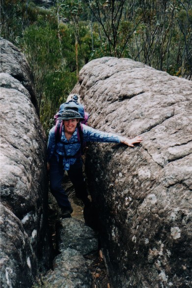
Karen Davis climbs through the narrow pass onto Mitchell Lookout
During the break Brett pointed out some of the points of interest from out vantage point, including Mount Bushwalker, one of the favourite walking locations for the Shoalhaven Bushwalkers, to which newcomer Colin replied that he had never visited. This brought an immediate reply from Brett of "You Virgin" which could become the title for any member of the club who has not taken this very popular walk. 10 minutes into our break we suddenly became aware that our group of 7 had suddenly become 6. Where was Ray? A quick search and name call revealed he had not disappeared into the bush for a call of nature, his pack was nowhere to be seen. It became obvious that Ray has had another 'Senior Moment' and had continued walking on when everyone else had stopped for lunch. Colin ran down the track calling his name, with no reply, so we had no choice but to postpone lunch, put our packs on and chase after him. We quickly made our way along the track as it descended through a rock field, loudly calling his name, Brett blowing on his whistle, but still no reply. Suddenly, 10 minutes from Mitchell Lookout we came across a sloping rock platform and found Ray sitting alone eating his lunch - We all dropped packs and joined him to finish our lunch. Ray had continued on thinking the rest of us had somehow got well ahead of him, then realising he had gone on ahead decided to sit it out and wait for us to catch up, he had not heard our calls due to his hearing problems. I think Ray was lucky he stopped when he did, as a little further on the track divides and he could easily have taken the wrong turn.
With lunch finished we continued on and very shortly found ourselves at the edge of The Ravine, a steep section of rock that has to be negotiated with care as you descend to the gully below. The slope is often very slippery, especially after wet weather, so we were thankful there had been no rain for some time. At the bottom of the ravine we followed a faint cairned track uphill through a forest floor of loose rocks, leaf litter, bark and rotting logs. As it levelled out the track became more defined and we made the long journey to the rocky platform of Folly Point, a section that never seemed to end. Eventually we reached a stone cairn and dropped packs. The cairn marked a small track heading into the undergrowth that eventually would lead us to the Folly Point camping area. Instead we walked south west for 5 minutes following a number of stone cairns to Folly Point Lookout.
Everyone was impressed with the views from the lookout. Straight ahead was the imposing structures of The Castle, Shrouded Gods Mountain and Mount Cole. To the right was Mount Elliott, Sturgiss Mountain and Quilty's Mountain, to the left was Mount Talaterang, Pigeonhouse Mountain and Byangee Walls. We could also pick out Crooked Falls, Mount Tarn and Mount Haughton. A lone Falcon, which Brett informed us was an Australian Kite flew up out of Hollands Gorge below us and landed on a rocky point not far away. None of the walking group but myself had been here before and I took great pride in being able to show these people something new, for it is usually the other way round with members of the Shoalhaven Bushwalkers showing me something I had not seen before. It felt good to repay the favour. We explored along the cliff edge for a short time, then returned to our packs.
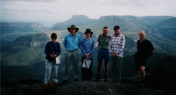
The Shoalhaven Bushwalkers group to Folly Point (Minus Paul Ellis who
was taking photo) standing on Folly Pointt Lookout
Left to Right - Sandra Kelley, Brett Davis, Karen Davis, Colin Taylor,
Ray Spratt & John Prior
It was a short walk to the campsite, following first a track through dense bush, then a well cairned rock platform before descending to a small wooded area beside a creek. We arrived right on 3.00pm and fought for prime campsites. As expected there was one too many tents and as I started to pitch mine I was joined by Colin who noticed there was enough room next to my tent for his. I tried to warn him about my snoring problem, but to no avail. Oh well, I did try and warn him. With our tents pitched I made my way to the rock pool to replenish my water supply. The walk in had been very hot and I had completely drained my 3 litre hydration bag. My new Katadyn water filter worked brilliantly and within minutes had completely topped up the 3 litre bag.
There was no rest with the Shoalhaven Bushwalkers. I was quickly called back to camp as we were going to do a quick walk down Watsons Pass. As I passed my tent I grabbed my camera and caught up with the rest of the group. To the south of the camping area we crossed a long rock platform, passing the visitors logbook just above the famous sink holes along the creek. Then we descended a deep crack in the rock and negotiated a couple of large rock ribs, descending off the last one using a length of chain and 2 metal pegs conveniently hammered into the rock. We then descended through the cliffline of Watsons Pass which was easier than I expected despite a couple of sections that required confident scrambling, one drop requiring a chimney manoeuvre. At the bottom the track descended steeply through the forest. Brett wanted to take a look at the Watsons Pass camping cave but daylight was fading and in my rush to catch up I had not grabbed my head torch. I was not keen on climbing back up in the dark. About halfway down, John decided he was going no further and stated he would wait. I decided to stay with him while the others continued on. We gave them 15 minutes to return.
The 15 minutes went by and there was no sign of the other group. John tried a couple of calls, with no answer so we decided to head back to the campsite. If need be, we could always start a search come morning. We slowly climbed back up the hill, taking our time to make sure we took the right gully back through Watsons Pass. Halfway up we heard the sound of voices below us so we waited for the rest of the group to catch up. They had successfully found the cave, right on the return time deadline and found it occupied by the owners of the two bikes we had seen earlier in the walk. We climbed back up the pass and made our way back to camp and prepare dinner.
The camping area had a good sized communal gathering area, complete with fireplace (right next to my campsite). While Brett & Karen were moving an assortment of rocks and logs for seating, Karen, whilst lifting a large stone found my missing Swiss Army Knife which had been lost on my previous walk here a few weeks ago - it had obviously slipped off the log I had placed it on and slipped under the lip of the stone. It was still in very good condition apart from some rust on the key ring. With darkness falling everyone prepared and ate their meals and sat around the campfire talking. One interesting conversation centred around which mountain was the 3rd highest in the world with Brett betting his right testicle the answer was Kangchenjunga. At the time of writing I'm still uncertain if Brett's new nickname will shortly be 'Lefty'. We sat or stood until after 9.00pm when tiredness overtook everyone after the long walk and we retired to our respective tents.
During the night I awoke to the sound of heavy rain on my tent. I hoped it was just a passing shower and I would greet a sunny day when I exited the tent next morning.
It was not to be. At 7.15am I unzipped my tent to see mud everywhere. The camping area was clouded in mist and Colin had erected a tarp over the communal area where everyone else had gathered to keep out of the light rain that was now falling and to prepare breakfast. I gave breakfast a miss, I wasn't really that hungry. Colin commented on my snoring ability during the night and admitted he should have heeded my warning, Brett & Karen who had camped 20 metres away claimed they could hear my snoring above the heavy rain, but the rest of the group never heard me (who was telling the truth?)
Karen had wanted to visit Munnuldi Falls this morning and had arranged a 7.00am wake up for those interested in going, but the wet weather had thwarted those plans. John had wanted to return to the lookout and photograph the sunrise over the Castle, but his plans were thwarted also. It was decided we would head out as best we could in the lousy conditions. The wet weather putting a damper on all exploratory plans for today. It was a wet, muddy and miserable experience dismantling the tent and packing the rucksack - so much for a lighter pack, the wet tent well and truly making up for all the food eaten yesterday. By 8.50am we were all packed and ready to move off.
No one was really keen, despite wearing wet weather jackets to take the lead and cop the first load of water from the rain saturated scrub, though for most of the walk back, John valiantly took this job with myself, Brett and Sandra taking over from time to time. By now the rain had eased considerably and we picked up our pace through the 'Misty Mountains'. Within one hour we had reached the ravine which by now was quite slippery and we gingerly climbed our way up. We wasted little time ascending to Mitchell Lookout where we stopped for a quick morning tea before continuing. The low cloud covered everything and visibility was restricted to around 30 metres, it was also very cold. We crossed the small valley and ascended the other side and continued on towards the main road at Newhaven Gap arriving right on midday. I was thankful for the heavy fog, you did not have that awful view of the access road winding and ascending way into the distance from the high vantage point of the trackhead.
We gamely plodded on, some of us very keen to put on some
pace to keep warm, others happy just to take their time. At 1.15pm we arrived
at the campsite just 600 metres from the carpark. With its sheltered benches,
water tank and toilet, an opportunity for a comfortable lunch could not
be ignored. It was just after 2.00pm when we arrived back at the vehicles
and thanked Sandra for a wonderfully enjoyable weekend (despite the wet
weather and the access road).
RETURN TO WOMBATS HOME