Crew: Karen Davis (Leader), Brett Davis (Co-leader), Paul Ellis (Advisor), Sue Bosdyk, Julie Davison, Lani Imhof, Michael Smith, Peter Farrell & Colin Taylor (Official Photographer)
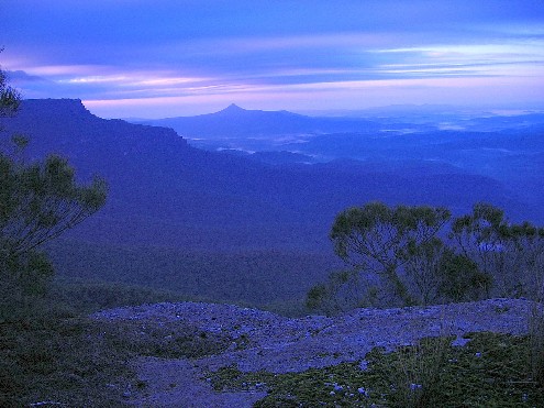
On Saturday 14th May 2005 I joined up with the above Shoalhaven Bushwalkers for two days walking in the Budawangs. I drove to Brett & Karen Davis' place where I would leave my car and travel with Brett & Karen in their car to the Wog Wog trackhead. Sue Bosdyk was also there for the 7.30am deadline. Our drive would take us along the gravel Turpentine Road to the intersection of the Braidwood Road where we would meet up with the rest of our walking companions, then the dreaded drive along the potholed and corrugated Braidwood Road to Nerriga and then along bitumen to the intersection of the Mongarlowe Road and following this gravel road for about 5km to the Wog Wog trackhead. The weather was overcast, but there was little threat of rain. In fact, during the first day we would experience cloudy conditions, followed by breaks of warm sunshine with the occasional cool breeze.
At the meeting place at the intersection of Turpentine & Braidwood Roads we met up with our co-walkers and all signed the walk register & waiver forms. Colin Taylor (our gadget man) brought out a couple of walkie talkies for use during the drive. These were useful in contacting the other vehicles to warn of bad road conditions ahead, or in the case of breakdown. Thankfully they weren't required, though they did get some use. During one section of rough corrugations, Karen radioed back to Colin's car warning of the hazard. The reply that came back caused much mirth in our car. Julie, came back with the reply that Karen's message was interrupted by "Static", but what we heard sounded more like "these corrugations are making me ecstatic". The drive through Sassafras revealed only one sighting of an Emu.
We finally arrived at the small village of Nerriga and stopped at the roadside opposite the pub for a quick chance to stretch our legs. The air was quite chilly outside so we hoped it was a short stop. I heard Brett call "Okay, time to go", I quickly made my way around the car to take my seat and realised Brett was only joking for the sight that greeted me made me quickly turn around and return to the other side of the car. Sue had decided to take a nature call behind the nearest tree, but it was in full view from the roadside.
The drive along the bitumen for the next 20km was luxury after the bumps, bangs, ecstatic corrugations and dust of the road east of Nerriga. It was 9.20am when we finally arrived at the car park at the Wog Wog trackhead. It was decided to have an early morning tea here before moving off down the track 20 minutes later.
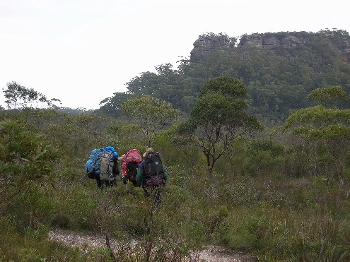
We passed the rock slab with the bronze plaque commemorating the 1998 addition of Corang Peak to the National Park at the trackhead and descended to Wog Wog Creek, crossing this narrow stream using small rocks as stepping stones. Then it was the ascent along a narrow and overgrown track onto the ridge above, before the track opened up after passing through an old fence line. This is an old vehicle track that has now become no more than a narrow foot track. We find ourselves walking through eucalypt forest with some species of snowgum and later, stringybark. Our walking group had split up, some of us putting on some pace to warm up in the chilly air, some content to take their time and set an easy pace.
We soon arrived at a series of rock outcrops known as Tinderry Rocks and stopped at the first of these for another short morning tea break, taking the chance to climb up and take in some views south across the farmlands and pine forests. About 100 metres further on we noticed a small track heading uphill to our left leading to another outcrop. We dropped packs and went to explore, finding an easy climb up onto the top at the rear, we found ourselves on a large flat area with even better views, including the distant Corang Peak to the south east. It is thought that this is the proper Tinderry Lookout despite the sketch map stating it was at our earlier stop. After descending and completely circumnavigating the large outcrop we returned to our packs and continued on.
Very shortly we arrived at a small track intersection marked by the letter 'T' on the trunk of a large tree. The track to our left is the one we would be returning on tomorrow. We now continued straight on, heading uphill to a large conglomerate outcrop which in the past has been given the name 'Borstal's Pass'. The track makes its way through this outcrop, descends the other side and then ascends gradually onto Corang Plateau. We basically climb onto the plateau without realising it. The narrow track occasionally gives us glimpses of views on either side - north towards the Goodsell Basin and south towards Wog Wog Mountain and the pine forests around it.
Most of the track here is rock platform, though the scrub on the dirt track does crowd in on you as you fight your way eastwards. Corang Peak now appears in the distance. Some of our group were now getting quite hungry and called for an early lunch. A rocky spot was found, but I suggested a much better spot with a great view about 10 minutes down the track. Grudgingly some of the group decided to continue, but they were happy they had done so as when we arrived at the spot I suggested, we were greeted with a sizeable rock platform on the cliff edge with views south which includes some interesting rock platforms. Once seated, several asked if I could bring the sun out to warm them up. No sooner had this been asked than the sun appeared from behind the clouds to warm us up as we enjoyed our lunch break.
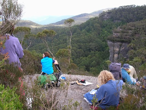
Lunch on Corang Pleateau with the great view. L-R Karen Davis, Julie Davison, Sue Bosdyk & Michael Smith
The track now ascended briefly to the northern side of Korra Hill where duckboards allowed us to cross the boggy ground. At the eastern end of Korra Hill is an open flat area which is used as an emergency campsite. The area has great views of Pigeonhouse Mountain to the south east. The track now ascends steeply to the top of Corang Peak. Sue and Julie were walking ahead of us as the track split into two. The left track taking us up the steep climb to Corang Peak while the right hand track circumnavigates the southern slope, meeting up with the peak track on the other side. Peter and I waited at this intersection for the rest of the group to catch up before moving on, but soon became aware that there was no sign of Sue or Julie up ahead. They weren't that far in front of us. It was obvious the girls had done a big "No No" and continued walking past the intersection without waiting, or had they been so busy chatting they hadnít noticed the track intersection? We called out to them and their reply soon returned. Sue & Julie had to back track to rejoin us as we made our way up the steep hill to the top of Corang Peak. The track here extensively repaired with timber to reduce erosion. This would be the steepest ascent of the entire weekend and I for one was glad to get it out of the way.
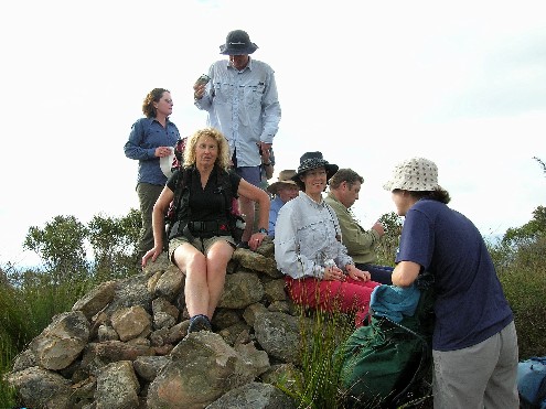
Our group on the top of Corang Peak. L-R Julie Davison, Sue Bosdyk,
Brett Davis, Peter Farrell, Karen Davis
Paul Ellis and Lani Imhof
At the top we emerged to find two young bushwalkers enjoying lunch with 360 degree views of the mountains and valleys of the Budawangs in this area. We could see as far as Currockbilly Mountain, Mount Budawang, Admiration Point, Pigeonhouse, Corang Arch, Burrumbeet Brook, Goodsell Basin, Broula Brook, Canowie Brook Valley, Quiltys Mountain, Hoddles Castle Hill, Mount Haughton, Mount Tarn, Bibbenluke Mountain, Mount Cole, Donjon Mountain, Mount Owen and The Castle. The two young bushwalkers must have been miffed as the serenity of their lunch break was interrupted by the appearance of 9 noisy Shoalhaven Bushwalkers. We had a short rest break to admire the views before we again shouldered packs for the descent on the other side, Brett warning certain members of our group about track intersections below.
I found myself in the lead as we made our way across the plateau, now heading north eastward on rocky ground as the track took us towards Corang Arch and the descent down the conglomerate slope. Corang Arch is found on the western side of the northernmost tip of Corang Plateau, not far from the descent on the conglomerate slope. It is easily found if walking close to the cliff edge. Access is through a small cave (forming another smaller arch) in the rock platform at the cliff edge. An easy scramble through the cave and down to the arch itself reveals a short easy climb onto the top of the arch or a short descent to a cave in the cliff between the arch and the plateau for excellent views through the hole to the valley below. We sat or stood on the arch while other members of our group took photographs from above. Colin surprised everyone by gaining access to the arch from the harder northern end. Colin was to amaze many of our group with his daring exploits on narrow rocks during the remainder of the weekend. This man has no fear around precipitous drops (I envied him completely).
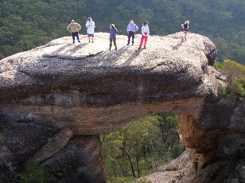
Ontop of the Corang Arch. L-R Paul Ellis, Brett Davis, Julie Davison, Peter Farrell, Karen Davis & Sue Bosdyk
We now moved on to the descent down the conglomerate slope. The route is not marked, but common sense shows the way. During the descent to our right we get a great view of Pigeonhouse through a gap between two large rock monoliths. We also get a great view of Profile Rock Hill below us. From this point the track becomes quite steep and some care needs to be taken. Close to the bottom on the descent my calf muscle cramped up causing some discomfort. I stopped to stretch out before continuing and had no further problems. At the bottom of the scramble a track on the right descends steeply to the campsites on the Canowie Flood plain. Here, a faint track to the left is seen. We will be taking this track tomorrow. We continue straight ahead crossing the very swampy Canowie Brook Plain on old rotting duckboards before ascending the small ridge next to Profile Rock Hill taking note of the face-like features on the southernmost point of the hill which has given it its name.
As we reach the top of the ridge we come to one of my favourite views in the Budawangs as we look across and up the Burrumbeet Brook Valley, flanked on both sides by large rocky ridges. We follow the track around the south western end of the valley before heading between the two ridges. We stopped at a track intersection. Below us was an open campsite, the track above led to some camping caves under the cliffline along the southern end. I asked Brett if we were camping in these caves, but Brett felt the larger cave at the eastern end of the valley would be more suitable. We continued on up the narrow valley. After some deliberation over which track actually led to the camping cave we finally found our selected spot. This is not too far from where the track ascends out of the valley and onto the Bibbenluke Ridge. An area noted for its virtual maze of walking tracks we dropped our packs under a large overhang at the bottom of the western ridge.
The large cave had ample firewood, was sheltered from the wind, but had a very dusty floor. It was obvious that some form of mining had been done here as horizontal shafts have been dug into the cliff line, both next to the cave and further around. The lines of these shafts were too perfect to be caused by nature. We now selected our sleeping spots, most of us dirty about carrying tents this far (though a necessity just the same) and helped in collecting firewood. Some of us took the short walk down to the creek to collect much needed water. The creek was hardly flowing, but there were a couple of spots where small cascades allowed clean water collection.
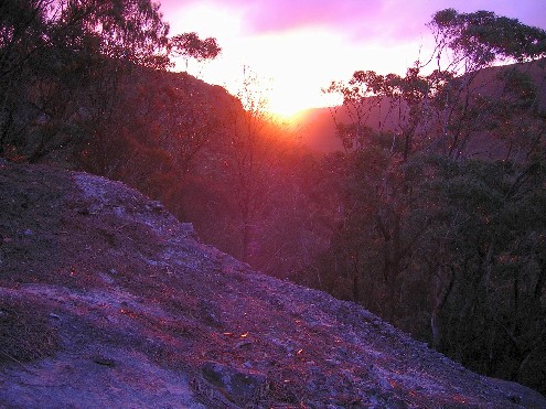
Colin's famous sunset from the ridge above our camping cave
We spent the next couple of hours preparing our sleeping areas, cooking up dinner and collecting more firewood. This was interrupted by Colinís sighting of a bright red sunset in the west. We all made our way along the base of the cliffline to get a better look. Unfortunately trees blocked the best views, but some climbed up the rock face to the top of the escarpment for a better look. It wasn't the perfect red sunset and it didn't last too long and we were soon back at the main cave organising our meals and starting the campfire. It was well and truly dark by the time we had finished our meals. Although the cave was well sheltered from the wind, one soon felt the chill when venturing outside. Dinner was marred only by Colin's accident as he burned his fingers while moving the hot handle of his billy - lucky we had a couple of nurses in the form of Sue and Julie who quickly administered first aid. Both came in for much attention during the weekend as Karen aggravated her troublesome foot injury during the trip. We stood or sat around the campfire telling jokes and stories, or in the case of several of our party, held a farting contest which was considered a tie between myself, Sue and Michael (though some believed Sue won on merit due only to noise volume). By 7.30pm most of us had started to get into our sleeping bags. The clear night sky was now shrouded in heavy cloud and I hoped tomorrow wouldn't bring rain.
It certainly wasn't a great nights sleep. Sometime during the night I was woken by Sue shouting at me and hearing "Paul, you're snoring like a pig". Several times during the night I was woken by Sue ordering me to turn over. Apparently my snoring was quite loud and at one stage it had got me so disconsolate that I was affecting my companion's sleeping I even considered packing up and moving off to another nearby cave. I heard later that some had not heard my snoring, but had been woken by Sue's shouting. It did nothing to make me feel better, and for me, this was the lowest point of the entire weekend, even though I wasn't the only person guilty of snoring during the night. It's certainly time I did something about it. I awoke at around 6.45am next morning listening to everyone talking about my snoring problem - it did nothing to make me feel better and I must admit, until it was time we packed our gear up and started walking again I kept much to myself.
Early morning shot looking across the valley to Pigeonhouse Mountain from above our camping cave
For breakfast I cooked up some bacon, eggs & mushrooms on my Trangia stove. One thing I do like about two day walks is the chance to carry such luxuries in my rucksack. As there were no tents to dismantle, packing up was quite speedy and by 8.15am we were back on the track and heading back to the campsites on Canowie Brook where we stopped for a short break. The sky was again overcast but occasionally the sun would break through. It looked like the clouds would clear and we would experience a sunny day for viewing the cascades.
Some of our group admiring Profile Rock Hill from Burrumbeet Brook Plain.
L-R Paul Ellis, Julie Davison, Sue Bosdyk, Peter Farrell
We now followed a defined track across Canowie Plain. The track becomes quite swampy as it nears the large pool and cascade where water can be collected for the remainder of the walk. A little further on we pass an excellent campsite big enough for three tents and here we need to find the correct track as there are quite a few. The main track from here the track has deteriorated quite considerably and we have to force ourselves through thick scrub that is often head high or taller. The track too has deteriorated and become badly eroded and care needed to be taken to prevent a mishap. The track ascends to a rocky ridge and around the other side it ascends further and we can hear the sound of waterfalls. At one stage Brett, who had forged ahead to make sure we were on the correct track had stopped to film our progress through the difficult scrub. Sue, unaware she was being filmed until the last moment, called out "You Bastard" as she realised she was being filmed. Brett assured her that her comment had been retained on film for posterity, and could well be featured on the Annual Club photo & movie CD.
We dropped packs on an open rocky area that had views down Broula Brook. We backtracked to a small side track that descended to a large rock rib, from the top of which we all gathered for one of the best views on the Corang River. The rib drops precipitously to the river far below, but the views include three impressive waterfalls just below the junction of the Corang River with Canowie Brook. Colin again amazed us with his temerity by scrambling to the narrowest edge of the rib for better views. He was soon joined by Lani, but Michael and I (who had less than perfect heads for heights) preferred to remain at the widest section and enjoy what views we could.
The first cascades on the Corang River not far from the intersection with Canowie Brook
Returning to our packs we continued uphill for a short distance before finding the cairned route down to Broula Brook. We crossed the brook and ascended the next small ridge. On top was another rocky platform where it was decided we would stop for morning tea. With the sun shining down on us we relaxed with views of the Corang River and the Goodsell Creek area. The track from here descended to a small campsite next to a dry creek. We crossed the creek and ascended a small rocky slope. It was here 3 years ago that Brett, Gary and I had needed to take a compass bearing to take a negotiable route to the cascades on the Corang River. Brett was even commenting that after this ridge, there would be no track. However, to our immediate surprise upon reaching the top, we found ourselves on a well defined walking track. Surely this track hadn't been here 3 years ago, if so, how the hell could we have missed it. Incredulously we followed the track through the scrub and it wasn't too long before we arrived at the large campsite near the cascades. It was only 11.00am, too early for lunch, so we dropped our rucksacks, grabbed our cameras and went to explore the cascades.
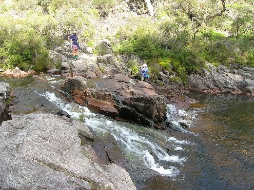
Lani & Julie at the 2nd set of cascades
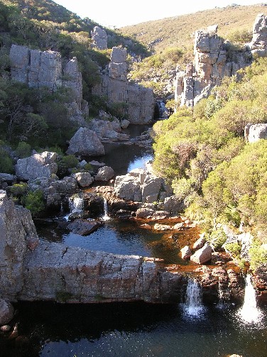
Next to the campsite the river forms a large pool that would provide an excellent swimming hole in summer. We followed a small track along the river bank to the first of the cascades. Here the Corang River drops in a series of spectacular cascades, creating cool rock pools. There are about 4 series of cascades, all very photogenic before the river makes its final drop via a spectacular cascade. Access to all cascades is via a negotiable route either along the rocks on the river, or the narrow rocky river bank. Above us was the corrugated remains of an old water race that was used in the 1880's for gold sluicing. Of course Colin played Mountain Goat, amazing us with his agility as he climbed up the steep rocky incline to locate the water race. He signalled to us confirming he had found it.
Returning to the rucksacks we had our lunch break. I was mystified why everyone was amazed at me getting out my Trangia stove and frying up the last of my bacon rashers to put on my bread roll. Hadn't anyone ever heard of a "bacon buttie?" It was delicious, I could have used some HP sauce though.
The clouds were starting to gather at 1.55pm as we headed out back to the cars. From the campsite the track (one of many) ascends onto the ridge heading out along the Goodsell Creek area. It quickly levelled out. The track is well defined and passes through open timber for 3km descending and ascending only at 4 creeks, the major one being Goodsell Creek before the track arrives at the intersection with the tree marked with the letter 'T' we had passed yesterday. We passed a school group heading into the Cascade camping area during the walk out and several of the students were pleased to hear their destination wasn't too far away. The ascents out of each creek tested the lung capacity, the worst being the stony scramble out of Goodsell Creek itself, though hardly as tough as the ascent onto Corang Peak.
We had a quick break at the 'T' junction before heading the last 3km back to the cars at Wog Wog trackhead. This was basically the most boring part of the weekend as we were now walking back along a section we had walked in on yesterday. Sue and Peter took this chance to stretch their legs and put a bit of speed on while everyone else kept up a nice steady pace. We arrived back at the cars at 3.25pm and after a group photograph we headed home. We beat the rain which bucketed down just before 6.00pm.
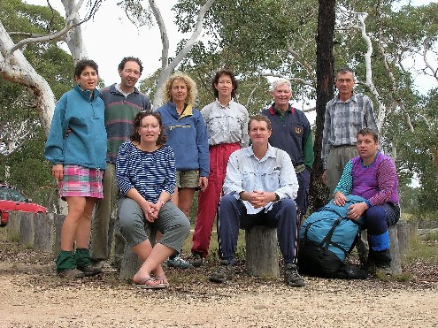
9 intrepid hikers at the car park after 2 most enjoyable days. L-R Lani
Imhof, Michael Smith, Julie Davison,
Sue Bosdyk, Karen Davis, Brett Davis, Peter Farrell, Colin Taylor,
Paul Ellis
It was a most enjoyable 2 day walk in one of my favourite
walking locations. Is it any wonder I return here time after time, year
after year. Many of our group enjoyed the steady pace and the fact there
were many stops to take in points of interest. There was certainly plenty
to see and there was much more we didn't, but there's always next time.
RETURN TO WOMBATS HOME