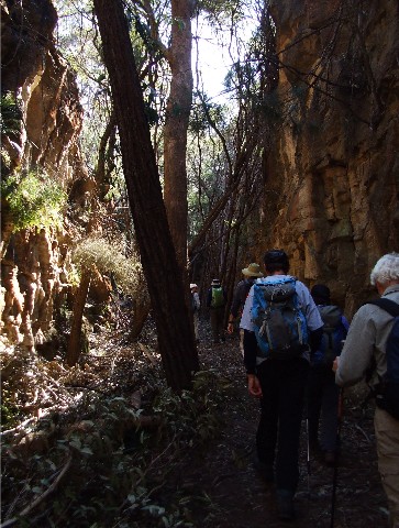
Shoalhaven Bushwalkers making their way through Casuarina Cutting
At 9.00am on 30th July 2011, Gary Williams and I joined 7 other Shoalhaven Bushwalkers for a day walk along the Box Vale Mine Tramway walking track near Mittagong on the NSW Southern Highlands. We met the others at Mittagong Caravan Park and then drove out to the trackhead west of Welby, just after crossing the motorway we turned an immediate right off the main road and made our way to the car park and picnic area. There are a number of informative information boards here, from maps of the main track and surrounding area to details of the local flora and fauna. It was a cool but sunny day, hardly a cloud in the sky. With us were Brett & Karen Davis, John & Jillian Souter, Ian & Linda Parker and Kynie Evison.
Here is a little run down on the history of the Box Vale track . In 1883, five years prior to the Boxvale Tramway being built, the Mittagong Coal-mining Company (Limited) took steps and opened a new seam of coal situated 520' (158.5mts.) below at the base of the incline. The seam was said to be twenty-nine feet thick. It was well known that the quality of the coal was of very high standard, nearly if not equal to the best Newcastle coal. In the same year a workforce prepared the ground for the erection of a stationary engine on this spot and the construction of the incline to the mouth of the coal mine below. The Boxvale Track crosses Nattai Creek then follows the embankment of the Boxvale Railway. The line, of standard gauge, was built in 1888 to carry coal mined in Nattai Gorge the seven kms to the main southern Line at Mittagong. The line passes through several cuttings and a tunnel 84 metres in length. It ends at the "incline", by which coal was brought up from the gorge. The Colliery probably had its heyday in 1888, when 100 tons of coal per week were shipped to Melbourne during a coal strike. The Colliery was closed in 1896 and the railway abandoned. The last part of the line was opened as a walking track in 1996. Design and finance were by Nowra Lands Office.
We set off down the signposted track but almost immediately we stopped to take in the views of a reservoir that supplies water to Welby. From here we followed what was originally the railway line, now nothing more than a wide track as it descended to and crossed Nattai Creek via a series of small footbridges. The surrounding vegetation was mainly Eucalypts and casuarinas and in places where small ascents and descents could be found, they were negotiated via steps courtesy of NSW Lands.
Shoalhaven Bushwalkers making their way through Casuarina Cutting
We continued following the Box Vale track walking through a small cutting before reaching the much deeper Casuarina Cutting where cameras were brought out for a series of photographs. Long after the the tracks have been removed, their place has been taken up by trees where once rail cars trundled along under steam. We crossed along a high ramp above the forest before we came to a track intersection. A turn right would take us to Forty Foot Falls, a spot we planned to return by later today, according to our leader. We went straight ahead following the now narrow tramway as it descended to Kells Creek where we stopped for a short drink break. It was here that we suddenly realised that Gillian was missing, so John backtracked to see if he could find her while we patiently waited.
A little while later John returned having not found Gill. He was concerned though that trying to catch us up, that she had turned right and taken the track to Forty Foot Falls. John had followed this track until he reached the T Junction and then had no idea which way Gill had gone. We had 2 options, wait for Gill to return or, as Karen suggested, do the walk in reverse and try to catch up with her. At first, Brett was not keen on this but as time went by we really had little choice but to take the latter suggestion - do the walk in reverse visiting Forty Foot Falls first then making our way along the Nattai River to where we would ascend back up the escarpment to the Box Vale Track. In the end this turned out to be the best idea, but more on that later.
We backtracked back to the intersection where it was obvious the signage is not that obvious for those following the Box Vale Track. There were large signs pointing right to Forty Foot Falls, but the small red Box Vale marker tags were almost invisible compared to the former unless you were looking for them. No wonder Gill had continued right. We made our way to the T Junction where Linda used a stick to carve arrows and Gills name in the sandy track, in case she had again turned right. We turned left and followed the trail and after a few hundred metres a familiar figure came into view. Gillian had been located.
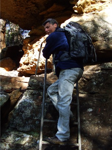
Gary Williams descending the ladder that negotiates a route from the top to bottom of Forty Foot Falls
We now followed the track eastwards until we could hear the sound of rushing water and I immediately recognised this spot. Last year we had visited Forty Foot Falls from a different walk and I recognised the track and ladders. We had arrived at the cliff edge at the top of Forty Foot Falls. We now negotiated the steel ladder that helped us descend the more difficult part of the rock face then followed the steps cut in the track which descended to the bottom of the falls. Some interesting scrambling over a fallen tree and the usual rocks brought us to a ledge under the waterfall and again the cameras were out for a series of photographs.
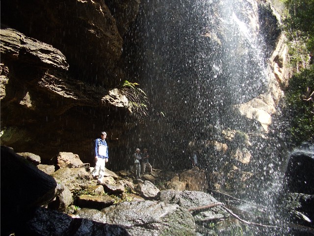
Below Forty Foot Falls - There was a lot more water than last year when it was just a trickle
The falls were running much more impressively after all the rain this year than the little trickle we had experienced 12 months ago. The sight was very photogenic. I took several shots from differing angles before we returned to the track. We now made our way above Nattai Creek descending another small rock face via a steel ladder before stepping over rocks onto a rock platform and then crossing Nattai Creek before ignoring a track straight ahead and turning left and following a track northward along the Nattai River. In places there were trees down which required negotiation. The track itself was reasonably well defined, though I did take a tumble on a slippery moss covered rock. No damage done save for a lightly skinned shin. We made our way along the river bank, our attention occasionally diverted by the appearance or call of a native bird.
On a couple of occasions we were able to cross the river on a series of half submerged rocks, which in places were quite slippery and we then followed the eastern bank of the river. We found a sunny spot on the track where there were rocks to sit and have lunch which became a 25 minute stop. On resumption we continued along the track and ascended through a picturesque arch in a large sandstone rock. We were not sure if the arch was natural or man made but there were possibilities it could be the latter judging by marks in the rock. The track above was narrow and care was taken as it wound its way above the river, ascending and descending. After my recent fall I took extreme care on the slippery sections but the track soon descended to what was obviously our final crossing point on the Nattai River.
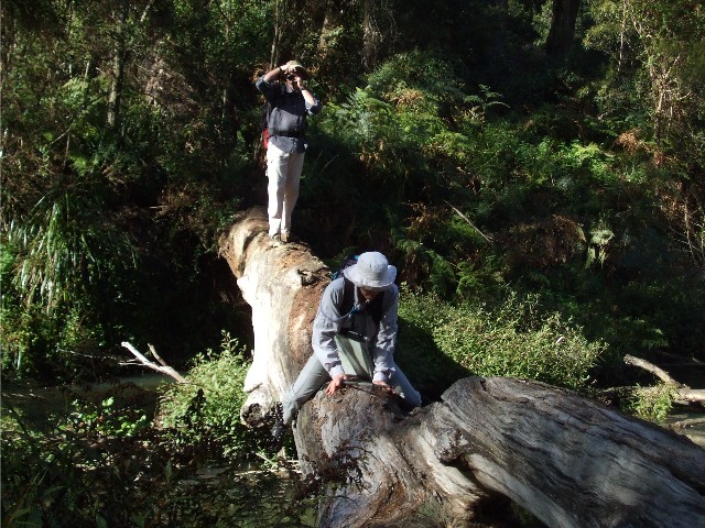
Karen negotiates a way across the Nattai while Brett takes photographs for posterior .... I mean posterity
Which way to cross was the question. The river was shallow enough here to cross with the minimum of wet footwear, the rocks small but negotiable. The other option was a large tree that had fallen across the river. Here good balance would be required. I opted for the rocky crossing, but John, Gillian, Brett and Karen opted for the tree, Karen negotiating on her backside for which I could not resisted the jibe "Stop Arsing Around".
We now followed a short track that followed a small feeder creek to the Nattai River, then suddenly we were faced with a sign that informed us of the ascent to the Box Vale track. What bothered myself and Gary was the sign stating the ascent (580 metres) but underneath was one work that chilled the blood - Difficult. - and difficult it certainly was. The track went straight up and it was narrow and stony and within metres the heart rate had risen considerably followed by much huffing and puffing. It was certainly steep, so steep that a steel cable was placed along the track to assist the walker during the climb. It just didn't seem to end. Every time we looked up the track seemed to continue ascending steeply. Gary and I plodded along as best we could. I utilised my trekking pole for purchase on the slippery stone covered slope, only occasionally using the cable. John amazed us by blazing away ahead of us and I knew it was only a matter of time before we would get overtaken. We took many breather stops, using the opportunity to take photographs as an excuse. First Brett, then Karen, then Ian and then Gillian went past, but we battled on. We thought it would never end and our lungs were going to burst. I later learned that the Canberra Bushwalkers lay claim the record time for this ascent was 13 minutes. I have no idea what kind of time Gary and I took but my guess is that it would be in the 20 minutes plus time frame.
I suggested to Gillian jokingly that having to do this ascent was all her fault, but in reality her getting lost was a godsend as having to do the original route would have meant a treacherous descent down the same incline which would have played merry hell with my dodgy knees at best. Despite the extreme difficulty of climbing I knew I would prefer this to the descent. Eventually we noticed the track was passing through a rock cutting and I knew we were close to the top and shortly after, quite breathless we stepped out on top of the ridge and found a tree log to sit on and settle the heartbeat. I would have to consider this ascent to be the steepest and most difficult ascent I have had to negotiate in over 26 years of hiking/bushwalking and I've done a few ascents in my time during those years.
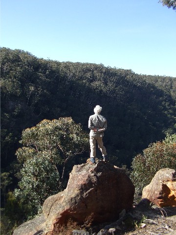
John stands atop a rock overlooking Nattai Gorge from the lookout at the end of the Box Vale Track
Nearby was another signpost stating a 600 metre walk to a lookout. We had just ascended a 580 metre ascent, a level walk 20 metres longer was going to be a doddle and shortly afterwards we all gathered at the safety fence at Nattai Gorge Lookout (Map ref - 640889) for some splendid views down the Nattai River Gorge. We took a long break here to enjoy the views and take note of some very early spring wildflowers, then it was back to the track and to follow the Box Vale Mine Tramway Walking Track back to the cars.
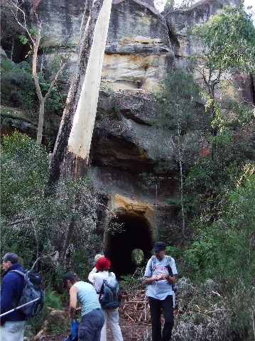
Shoalhaven Bushwalkers take a drink break or read the information board after passing through the old railway tunnel
The track was really enjoyable and after passing by a very large tree that had split during recent gale force winds we came across one of the highlights on this walk - the old railway tunnel through the rock face. Originally we had been told to bring our torches for the walk through, but some of us decided it wouldn't be necessary, the tunnel wasn't too long at around 84 metres. The walk through was most interesting but the light from the other end plus glow from a few torches used helped us get through. On the other side there was an information board on the history of the tunnel complete with an 1890's photograph of a train coming through.
John makes his way through Boulder Cutting
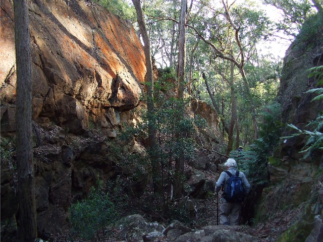
The track now passed through a series of very interesting
cuttings, both suitably named for what could be found through them, notably
Fern Cutting and Boulder Cutting. Much of the rock face which had been
cut by the workers when the railway was built shone in different colours
in the afternoon light. Gary and I discussed how a long distance track
like this would be an absolute joy to follow on a multi day hike. There
were ferneries everywhere and what was once railway tracks are now home
to some pretty large trees growing out of the track. The walking kept us
warm in the mid afternoon shadows as the cuttings were always out of the
sun. Very shortly we descended to Kells Creek and knew we had only a short
walk back to the car park where we arrived just after 3.30pm.